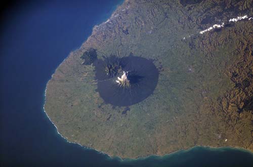
The dramatic circular outline of Egmont National Park was delineated in 1881, when a circle with a 6-mile (9.7-kilometre) radius was surveyed from the mountain peak for a forest reserve. Forested land outside the reserve was cleared and turned into pasture over the next few decades. In 1900 the mountain, with the Pouākai and Kaitake ranges, became New Zealand’s second national park. This satellite view shows the broad curve of the Taranaki coastline.
Te whakamahi i tēnei tūemi
Reference: International Space Station Crew Earth Observations Experiment and the Image Science & Analysis Group. ISS006-E-40152
This item has been provided for private study purposes (such as school projects, family and local history research) and any published reproduction (print or electronic) may infringe copyright law. It is the responsibility of the user of any material to obtain clearance from the copyright holder.