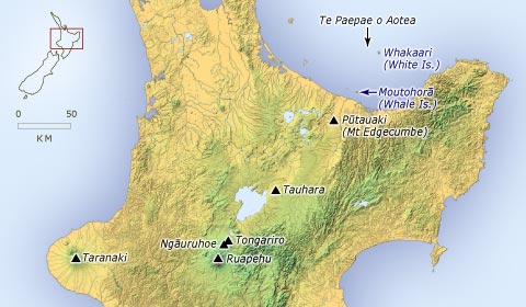
He rahi ngā kōrero a ngā tūpuna mō te takenga o ngā maunga o Te Ika-a-Māui. Nā Pei Te Hurinui Jones o Ngāti Maniapoto i homai tētahi kōrero mō Tongariro me āna wāhine e rua, a Pīhanga rāua ko Ngāuruhoe. Heoi, ka hiahia a Taranaki me ētahi atu o te kāhui maunga i ngā wāhine nei; ka pakanga ngā maunga. I te taunga o te puehu, kua marara kē ngā maunga rā ki ngā pito o te whenua, ki ngā wāhi tū ai rātou i tēnei rā. Ka tau a Whakaari, rātou ko Paepae-o-Aotea, ko Moutohorā ki waho atu o Whakatāne. I tau a Pūtauaki ki uta, ki te tonga o Whakatāne.
Te whakamahi i tēnei tūemi
Te Ara - The Encyclopedia of New Zealand
This item has been provided for private study purposes (such as school projects, family and local history research) and any published reproduction (print or electronic) may infringe copyright law. It is the responsibility of the user of any material to obtain clearance from the copyright holder.