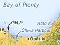

Standing on Kōhī Point, high above the ocean at Whakatāne, the onlooker scans an impressive expanse of coastline. Far to the west, at the entrance to Tauranga Harbour, lies Mt Maunganui. Looking north out to sea, Mayor Island is discernible, and closer in, Mōtītī and White (Whakaari) islands. Moutohorā (Whale Island) dominates the foreground. To the east, the spurs of the bush-clad Raukūmara Range drop sharply to the coast.
Shared names
Several landmarks in Bay of Plenty are known by both their Māori and English names:
Mt Maunganui – Mauao
Mt Edgecumbe – Pūtauaki
Mayor Island – Tūhua
White Island – Whakaari
Whale Island – Moutohorā
A line of territory
More than almost any other New Zealand region, Bay of Plenty is defined by a coastline, rather than an area. The Māori inhabitants, descendants of the people of the Mataatua canoe, identify the boundaries in a saying: ‘Mai Ngā Kurī a Whārei ki Tihirau’ – from the Bowentown Heads to Cape Runaway. For their Pākehā neighbours the line was first the sea and then the railway, but it has since become a highway.
Regions within the region
The region is commonly divided into the western Bay, centred on Tauranga, and the eastern Bay, centred on Whakatāne. The regional council's boundaries also include the Rotorua district, which lies within the Volcanic Plateau region.
Bay of Plenty can be subdivided into several zones:
- Out to sea, the offshore islands.
- Hugging the coast, beaches, dunes, shallow harbours, estuaries and wetlands.
- Inland, alluvial plains, the hub of production and population.
- Further inland, rugged, dissected, often bush-clad ranges, notably Kaimai in the west and Raukūmara and Huiarau in the east. Most of Huiarau is the domain of the Tūhoe people.
Two names – two worlds
The ancestors of Māori originally voyaged from Eastern Polynesia to the region, and other parts of New Zealand, around 1250–1300 CE. They named the Bay Te Moana a Toi (the sea of Toi). Toi, or Toitetuatahi, was an early explorer to whom Māori throughout the North Island are linked.
Later, Pākehā knew it as the Bay of Plenty. The name was given by Lieutenant James Cook, who circumnavigated New Zealand in the Endeavour in 1769–70. Cook was alluding to the region’s abundant natural resources.
However, the name seemed over-optimistic in the 150 years after Cook’s voyage. Contact between Māori and Pākehā through missionaries and traders in the early 1800s turned to war in the 1860s. As a result, many tribes were dispossessed of their best land. Pākehā settlers arriving later found it difficult to make a living from a region that proved less productive than hoped.
In the 20th century, the drainage of swamp land, improved communications and the development of forestry helped the region live up to its name. Holidaymakers and retired people flocked to the golden sands along the coast. But the economic advances have not been shared equally. The Bay’s Māori and English names continue to reflect two different worlds.