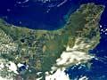
The sea comes first in the Bay of Plenty. A sweeping curve defines the bay, from Ngā Kurī a Whārei to Tihirau (Bowentown Heads to Cape Runaway). A more generous definition would begin further north at Ahuahu, the largest of the Mercury Islands, off Whitianga.
Volcanic features
The volcanic zone extends beyond the coast to the sea floor. The three volcanic islands – Mayor Island (Tūhua), Moutohorā (Whale Island) and Whakaari (White Island) – are prominent reminders of this. Recent work by the National Institute of Water and Atmospheric Research has shown a zone of faultlines through Moutohorā to White Island and beyond.
The coast from Katikati to Ōpape (not far east of Ōpōtiki) is a curve of sandy beach. It includes Matakana Island, but is interrupted by volcanic promontories at Katikati entrance, Tauranga entrance, Maketū and Whakatāne.
Harbours and wetlands
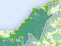
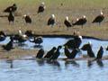
Tauranga and Ōhiwa harbours formed when the sea level rose after the last ice age, filling the river valleys. The harbours are very shallow, with large areas of mudflat and stunted mangroves exposed at low tide. The southern limit of mangroves is just south of Ōhiwa Harbour. Ōhiwa Harbour and Maketū, Kaituna and Waihī estuaries are major feeding areas for migratory and local wading birds, including the New Zealand dotterel.
Swamps developed around the Tarawera, Rangitāiki and Whakatāne rivers, and around the lower reaches of the Kaituna and Pōngakawa rivers. For Māori these wetlands provided food – shellfish, fish and birds. But for Europeans they limited both settlement and overland communication.
Most of these swamps were drained in the first half of the 20th century in government-funded projects. Recently there have been initiatives to restore the wetlands, which are important habitats for indigenous plants, birds and animals.
Climate
Coastal Bay of Plenty has one of New Zealand’s mildest and sunniest climates. Tauranga's mean annual rainfall is 1,198 millimetres, and it averages 2,260 hours of sunshine.
Soils
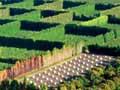
The volcanic ash that covers much of the region makes good soils, particularly where time has allowed the weathering of the ash into clays. The climate helps. Coupled with the high soil temperatures, these volcanic loams are suited to subtropical horticulture. This is particularly the case around Te Puke. Soils at Ōpōtiki and Katikati resemble those at Te Puke, but do not hold quite as much moisture.
The soils of the lower Kaituna and the Rangitāiki developed through the erosion of pumice, deposited from volcanic eruptions. The fertile plains in the east have been built up from the greywacke rock of the main dividing range.
Rising from the ashes
The Bay of Plenty’s kiwifruit industry prospered first at Te Puke because of the district's moist, free-draining soil. The top layer contains volcanic ash from the Kaharoa eruption (around 1314 CE), and the subsoil contains much older, weathered volcanic ash.
Lowland vegetation
When Europeans arrived the original vegetation cover included magnificent stands of kahikatea on the river flats. However, it has long since been displaced by introduced grasses, shrubs and trees. Some remnant forest, including pūriri, nīkau and karaka, can still be found on the lower hills, while the scarlet-flowering pōhutukawa dominates the forest at the coast.