
Invaders from the north
In the 19th century the area between the Whanganui River and Kāpiti Island saw two large-scale human movements.
1820s: tribal migrations
Armed parties of Ngāti Toa and Ngāti Raukawa from the Waikato region came into Manawatū and Horowhenua and challenged the local people for their lands.
1840s: European settlers
The invading hapū were attracted by the prospect of fruitful contact with European ships and their crews around Cook Strait. An inflow of immigrants from Britain began in the 1840s, but it had only lapped at the edge of the region by 1870.
Te Rauparaha and Te Whatanui
The leader of the Tainui invaders was Te Rauparaha of Ngāti Toa. From 1822, with Te Āti Awa allies from Taranaki, he challenged the local tribes – Ngāti Apa, Rangitāne and Muaūpoko.
While Ngāti Apa were partly protected by kinship links with Ngāti Toa, Muaūpoko and Rangitāne resisted, and paid a heavy price. A group of Ngāti Raukawa, led by Te Whatanui, joined Ngāti Toa in the south. Te Rauparaha was related to Ngāti Raukawa through his mother and a chief of the tribe. Rangitīkei, Manawatū and Horowhenua were won by occupation.
Te Whatanui was a benign overlord: he allowed Ngāti Apa to share territory with Ngāti Raukawa, negotiated a peaceful settlement with Rangitāne at Hotuiti, and placed the few remaining Muaūpoko people under his mana. He allocated them a small piece of land around Lake Horowhenua, bounded by Ngāti Raukawa settlements to the north and south. Together, Rangitāne, Muaūpoko and Ngāti Raukawa engaged with Pākehā in the flax trade, forming many settlements along the lower Manawatū River.
Pākehā arrivals
The Māori newcomers were still determining land entitlements, with some sharp quarrels, when the London-based New Zealand Company became active in the region in 1839.
The company bought 62,000 acres (26,000 hectares) in the lower Manawatū from Ngāti Raukawa, but most of the sale was later voided. It had come after the 1840 signing of the Treaty of Waitangi, under which only the Crown could buy land from Māori.
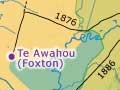
The company’s energies went into the Whanganui settlement and the nearby Rangitīkei district, which was sold by Māori in 1851. A small settlement at Paiaka, near present-day Shannon, did not survive the 1855 earthquake. The few settlers there moved to Te Awahou (later named Foxton) on the coast, where Māori sold a block of land to the Crown in 1859.
The Kebbel steam mill
When Manawatū Māori saw the steam sawmill being built by the Kebbel brothers at Paiaka in the 1840s, it reminded them of the bubbling springs in the Taupō district:
‘[They] displayed the keenest interest in what was going on, and when the cast-iron chimney, forty feet high, rose from out of the heap of angles, and the steam was sent hissing through the pipes, the recollection . . . came back [of] he puia mokai, i.e. ‘tame boiling spring’. 1
At the end of the 1850s around 85,000 acres (34,000 hectares) – about half the unforested land between the Rangitīkei and Manawatū rivers – was being leased by Pākehā from Māori owners for grazing sheep and cattle. The few Europeans were shepherds, or ferrymen at the river crossings on the coast route from Wellington to Whanganui – the only ‘road’ before the 1870s.
Land selling
The leased and other land west of the ranges was sold between 1864 and 1867. This was a different process to the fighting and subsequent land confiscation in Waikato, Bay of Plenty and Taranaki. Ngāti Raukawa did not have a long association with the land, but the negotiations over the 220,000-acre (84,000-hectare) Rangitīkei–Manawatū block still took time. There was debate over who had the right to sell. Rangitāne hapū maintained that they had retained ownership of significant land blocks even after Te Rauparaha’s conquest. In contrast, Ngāti Raukawa conceded Rangitāne’s right to sell the 250,000-acre (100,000-hectare) Te Ahuaturanga block in upper Manawatū.
Flax trading
The lower Manawatū remained rich in flax. A boom in 1869–70 improved the fortunes of Foxton. Manawatū may have been fairly described at the end of the 1860s as ‘the home of the flax trade and the terra incognita [unknown land] of everyone except the actual residents.’ 2 But with most of it now in Crown ownership, Pākehā colonisation could begin in earnest.