
Tribes
Before the 1820s the principal iwi (tribes) of the region were Rangitāne, Muaūpoko and Ngāti Apa. Rangitāne were found particularly in Manawatū, Muaūpoko in Horowhenua, and Ngāti Apa along the Rangitīkei River. Their traditions looked back to the Aotea and Kurahaupō canoes.
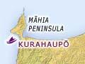
Canoes
The Aotea arrived at Pātea in Taranaki. Kurahaupō landed far away at Nukutaurua, near Māhia on the East Coast, a region to which many lower North Island traditions can be traced. One important route to Manawatū from Māhia followed the coast south to Cape Palliser, then west to Wellington and Rimurapa (Sinclair Head), and north up the west coast.
Tradition recalls that the explorer Whātonga travelled along this route. He named the area now known as Wellington after his son Tara – Te Whanganui-a-Tara. He then made his way up the west coast to the Manawatū River and through the gorge to return to his home in Heretaunga (Hawke’s Bay).
Rangitāne
Rangitāne was the grandson of Whātonga. He does not play a part in the history of Manawatū, except through his descendants.
Hau’s journey
Haunui (Hau) travelled south along the west coast in search of his wife Wairaka, who had fled with a lover. He reached Rangitīkei in one day (from which comes the place name: rangi – day, tīkei – to stride out), then Manawatū. Thinking a whistling noise was made by a hōkio bird, he named a place there Hōkio. He named Ōhau after himself.
Rangitane’s descendants included Tāwhakahiku and Māngere, and their cousins Rākaumauī, Poutoa and Tamakere. They were the first of this line to settle in Manawatū. A marriage between Whakarongotau, another cousin, and a Ngāi Tara chief cemented links with Whātonga’s descendants already in the region.
Muaūpoko
The Muaūpoko people lived in Horowhenua. One famous ancestor is the Ngāi Tara warrior chief Tūteremoana. The highest point on Kāpiti Island is named after him, and he is referred to in the saying, ‘Te tama whakaete tūranga rau, i tītī te ūpoko ki te kura a rangi’ (the young man who forced his way on to a hundred standing places and whose head was adorned with the glow of heaven).
Settlements and food
Excavations of early settlements reveal that at one time, the huge flightless moa was hunted along the coast. Following its extinction, food came from more modest sources – fish, shellfish, eels and birds.
Songs and stories tell of journeys along the coast and rivers. Along with the Horowhenua and Waiwiwi lakes (the latter also known as Papaitonga after the island in it), these were the principal zones of settlement.
Eels were an important part of the diet. Much later, after migrating from Waikato, the Ngāti Raukawa leader and warrior Te Whatanui gave land to those he had defeated around Lake Horowhenua. To keep control of the supply of eels, he excluded the Hōkio stream from this gift.
Away from the coast and riverbanks, the dense forest cover prevented permanent settlement, but provided a ‘storehouse’ of berries, and birds such as kererū and kākā.