Manawatū and Horowhenua cover 4,000 square kilometres between the North Island’s main mountain range and the Tasman Sea. The region is bounded to the north by the Rangitīkei River and to the south by Kāpiti district.
Manawatū occupies the northern part of the region, and Horowhenua the southern. Palmerston North and Feilding are the main centres of Manawatū. Foxton and Levin are the main centres of Horowhenua. Both districts fall within the territory of Horizons (Manawatū–Wanganui) regional council.
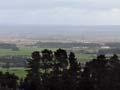
A view of Manawatū
The most striking views of Manawatū are gained from the roads that follow the ridges lying north-east/south-west: Ridge Road near Āpiti; Rangiwāhia Road near Peep-O-Day; the high ground above Mākino Road running north from Feilding; and the Mt Biggs road south from Halcombe to Mt Stewart, at the junction with State Highway 3.
- In the foreground lie the ridge spurs, the valleys and steep drops to the major rivers – Kiwitea, Ōroua, Pohangina.
- To the east are the summits of the Ruahine and Tararua ranges. Both lose height – and forest cover – near the Manawatū Gorge.
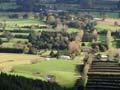
- To the immediate south are the lower courses of the Manawatū and Ōroua rivers, and the wide plain that they have formed.
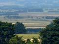
A view of Horowhenua
From Heights Road, which heads into the Tararua Range just south of Shannon, the whole of Horowhenua is laid out – the rolling country between Shannon and Levin, Levin itself and Lake Horowhenua.
Behind are the peaks of the Tararua Range and in front the curved Tasman Sea coast, banked by sand dunes and forest. In the far distance is the island of Kāpiti, sometimes looking like a land-bound mountain.
Significance and size
Manawatū and Horowhenua do not often feature on lists of New Zealand’s most scenic or compelling places. In many ways the two regions are ‘average New Zealand’, neither big city nor rural. Close up, their landscapes have much physical and human interest.
‘The’ Manawatū?
Some North Island districts are called ‘the’ Manawatū, ‘the’ Waikato. Others are referred to simply as ‘Auckland’, ‘Taranaki’, ‘Wellington’. In recent times the distinction has blurred, with ‘the’ disappearing (Waikato, Manawatū) or being added (‘the Hawke’s Bay’, ‘the Taranaki’).
Manawatū
Manawatū is one of the smallest regions in the country, even including Horowhenua. The main centre is Palmerston North, which developed later than towns such as Wellington and Whanganui. The Ruahine and Tararua ranges were a barrier to links with eastern districts. The Manawatū Gorge was roaded and railed by 1891, but both routes could be closed by slips.
Horowhenua
Horowhenua’s largest centre is Levin. The region has been regarded as part of Manawatū, but it also has its own local institutions.