The landscape in 1840
In 1840, when European colonisation began, forests covered the interior, and there were dunes, grassland and swamp on the coast. The most stable sand dunes were covered in mānuka, flax, toetoe, cabbage trees and bracken fern. Kahikatea and pukatea were the dominant trees on the floodplains of rivers and wet sand plains, but where the land was well-drained tōtara, tītoki, ngaio, kānuka and akeake flourished.
In low-lying, inland Kairanga, the trees were mainly podocarps – tōtara, rimu, kahikatea – and also tawa. Flax, toetoe and raupō (bulrush) grew in open swampy locations. Towards the Ruahine Range, in the Pohangina valley, tōtara grew in the lower areas, and other podocarps and tawa higher up the slopes.
Māori food sources
Māori used the coast as a source of shellfish, the rivers and streams for eels, and the forests to obtain birds, particularly kākā (parrots) and kererū (New Zealand pigeons).
Change after 1840
Between 1870 and 1910 there was a massive forest clearance to make land available for the settlers. Indigenous trees gave way to European grasses, first on the drier bush-cleared tracts and then on the drained wetlands. Native birds and freshwater fish became scarcer as the forests were felled and waterways channelled.
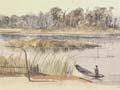
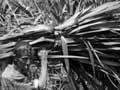
The first attempts at drainage around Makerua in the 1890s triggered the growth of native flax in place of raupō. Further drainage in the 1920s opened the way for pasture.
From dunelands to pasture
On dunelands the native cover was mostly spinifex and pīngao, with ground-hugging shrubs on the landward side. Further inland were toetoe, mānuka and shrub daisies.
From the 1860s the ground cover was replaced with pasture grasses for sheep and cattle to graze on. The dunes expanded but are now held in check by plantings of lupins, marram grass and California conifers – the macrocarpa (Cupressus macrocarpa) and radiata pine (Pinus radiata).
Flood control
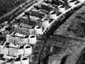
In the 20th century, swamp drainage and flood control involved major engineering work in Manawatū, culminating in the building of the Moutoa sluice gates and floodway between 1959 and 1962. This project remains one of New Zealand’s key flood-control structures. It covers 300 square kilometres of rural land, along with flood-prone areas of Palmerston North.
Giant dunes
The region’s sand dunes are aligned not with the coast but with the prevailing westerly wind. The longest stretch, 18 kilometres, is inland from Hīmatangi.
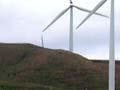
Wind farms
Rivalling Wellington as an accessible, windy environment, the mountain ranges on either side of the Manawatū Gorge have proved ideal for wind farms. In 1999, 48 turbines were installed, and 110 were added in 2004. Manawatū provides 300 megawatts of New Zealand’s total installed wind-farm capacity (690 megawatts).