Mountains
The eastern boundary of Manawatū and Horowhenua is the summit ridgeline of the Ruahine and Tararua ranges. These mountains are old greywacke blocks, like the ranges further north and the Southern Alps.
Manawatū River
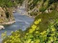
The mountain ranges are separated by the Manawatū River. Rising east of the main North Island ranges, it runs through the spectacular Manawatū Gorge. Known to Māori as Te Āpiti (the narrowing), this is the region’s most striking natural feature.
Over the years there has been debate over how the gorge was formed. The river may have cut into the mountains, but the preferred explanation is that the mountains rose on either side of the river. As they rose, the river maintained its course by cutting down into them. The mountain uplift has probably been happening faster in more recent geological time.
River terraces and plains
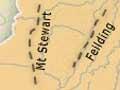
The Manawatū River’s main tributaries are the Ōroua and the Pohangina. Some of the terraces along these rivers have formed anticlines (arch-like folds). These are easiest to see around Pohangina, Feilding and Halcombe.
Underneath the arches
A syncline is a depression or dip in the landscape. An anticline is the opposite – a fold shaped like an arch or upside-down U. This can be formed when the earth is forced up, rumpling like a blanket. The Manawatū anticlines result from uplift on the river terraces west of the Ruahine Range. The Mt Stewart/Halcombe anticline is rising by just over 1 centimetre a year. It is unusual for such hill-building to be so visible – normally it happens far beneath the earth’s surface.
The terraces and alluvial plains on the lower Ōroua and Manawatū rivers were formed from sediment that gathered at the base of the mountains. It was then shaped by wind, ocean and river action over thousands of years. The plains are well-drained in the north, but were swampy in the south around Ōpiki, Makerua and Moutoa. Further downstream, at Foxton, the Manawatū River forms a large estuary.
Dunes and lakes
A line of sand dunes stretches 200 kilometres from Pātea in Taranaki to Paekākāriki, north of Wellington. The dunes are mostly under 15 metres high, but in places reach over 30 metres.
Along the dune edge lies a chain of lagoons and lakes. Many of the lagoons have been drained. The largest lake is Lake Horowhenua. Important wetlands within the dune belt are found at the Manawatū River estuary and behind Kūkū Beach, just south of the Ōhau River.