
Geologically, the Whanganui region is part of a basin that has filled over time with marine sediments and volcanic debris. It is sinking in the south and rising in the north.
Landforms
There are four broad landform zones:
- the Waimarino plain and adjacent volcanic areas
- part of the North Island main range
- an extensive belt of hill country covering two-thirds of the region
- a strip of coastal lowland.
Mountains and high plains
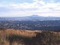
The Waimarino plain and Rangipō Desert both slope gently outwards from the base of Mt Ruapehu at about 900 metres above sea level. The Rangipō Desert is bounded to the east by the Kaimanawa Mountains, and the Waimarino plain merges with the hill country at about 750 metres. These areas comprise the southern end of the Volcanic Plateau. Most of their soils are formed from volcanic ash, and those around Ohakune are particularly fertile.
To the north-east and east the region is bounded by the Kaimanawa, Kaweka and Ruahine ranges, part of the North Island main range. They are mainly greywacke (hard grey sandstone), with a narrow zone of schist forming the core of the Kaimanawa Mountains.
Hill country
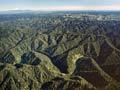
The region is mostly hill country, unlike neighbouring Taranaki and Manawatū, both of which are dominated by plains. The hill country comprises younger sandstones and mudstones, falling gradually from around 750 metres in the higher mountain areas to 150 metres near the coast. Rivers and streams have cut through this soft material, creating deeply entrenched valleys and a maze of sharp-crested ridges with uniform summit levels. Deposits of loess (windblown material) have contributed to the soils.
River record
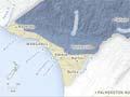
The terraces of the Rangitīkei River valley and the Whanganui coast provide one of the world’s most complete records of climate and sea-level changes over the last 2.6 million years. The highest and oldest formation is near Mt Curl, north of Marton. The youngest is closest to the coast, separated from the next terrace by a line of former sea cliffs.
Coastal lowland
The coastal lowland is 12 kilometres wide at Waverley and twice that at Marton. It comprises a series of uplifted marine terraces, river valleys and sand country. The terraces have been planed by erosion and dissected by streams and river valleys. They are overlaid with loess, volcanic ash and sand, and provide the region’s most fertile farmland, a continuation of the Manawatū plain and downlands.
The coastline north-west of Whanganui is dominated by high cliffs composed of layered shell beds and mudstone, known locally as papa. Dunes are found mainly near Waitōtara, and ironsand makes the beaches very black.
The coastal area south-east of Whanganui city is part of an extensive belt of dunes stretching south to Paekākāriki on the Kāpiti Coast.
In places the dunes have formed chains of small lakes. Sand build-up has advanced the shoreline westwards, especially south of the Turakina River.
Climate
The region’s climate patterns are influenced by its topography. The mountain zones in the north and west are the wettest and coldest area, with snow falling in the ranges and in the high country beyond Taihape in winter. The Desert Road, north from Waiōuru, is often closed by snow. Whanganui city, with less than 1,000 millimetres of rain each year, is relatively dry and warm compared with other west-coast areas, partly because of the protective effect of Mt Taranaki and the adjacent uplands.