
Wairarapa has three main landscapes: the western mountainous zone, the central lowlands and rivers, and the eastern uplands.
Western mountainous zone
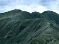
The Remutaka and Tararua ranges are part of the North Island axial range and stretch from the south Wairarapa coast to the Manawatū Gorge. They are formed from blocks of greywacke and argillite rock. The landscape is geologically young, as shown by 1–2-million-year-old marine and alluvial deposits on the top and western slopes. The mountains are more than 1,500 metres high west of Masterton, falling to 400 metres near the Manawatū Gorge.
Central lowlands and rivers
The lowlands comprise three basins:
- The Pahīatua basin extends north-east from Mt Bruce into southern Hawke’s Bay.
- The Masterton basin reaches from Mt Bruce to Carterton.
- The Wairarapa basin stretches from Carterton to Palliser Bay.
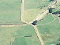
All were created over the last million years out of alluvial gravels carried by rivers from the Tararua Range. The rivers cut valleys and gorges to the basins, where they formed large fans, terraces and flood plains. The main rivers are the north-flowing Mangatainoka and Mangaone, and the south-flowing Ruamāhanga, Waingawa, Waiohine and Tauherenīkau. The Mangatainoka and Mangaone rivers flow into the Manawatū River. The others drain into Lake Wairarapa or Lake Ōnoke, on the edge of Palliser Bay.
Eastern uplands
Wairarapa’s eastern uplands – including the Waewaepa and Puketoi ranges – are made of uplifted sandstone, mudstone and limestone. The landscape has broad valleys and steep hill country, rising to 800 metres. Many slopes are unstable. Landslides are common after heavy rain, a problem made worse by deforestation and overstocking. To the south is the Aorangi Range, distinguished by its greywacke basement rock.
Earthquakes
Wairarapa is prone to earthquakes. The coast is about 90 kilometres north-west of the Hikurangi Trough, where the Pacific tectonic plate meets the Australian plate. As the plates collide, the oceanic crusts concertina, splintering into blocks along the Wairarapa and associated fault lines. Some of these have tilted upward to form the Tararua Range and eastern uplands. Wairarapa has a large number of strike-slip faults – faults that move sideways rather than vertically.
1855 earthquake
New Zealand’s largest recorded earthquake occurred in 1855 along the Wairarapa fault. It had a magnitude of 8.2 and (unusually) ruptured the surface. Evidence in the landscape shows that the fault moved as much as 6.4 metres vertically and 18 metres horizontally. It was the greatest deformation and rupture of land that geologists had ever known.
When the earth moved
In June 1942, a young Tīnui soldier was on leave from Carterton camp and taking a bath at his grandmother’s house. When the first quake struck the water began sloshing violently. His first impulse was to take cover under a door frame, but he feared exposing himself to his grandmother, so clung on in the bath. Back at camp, he was woken by his bed shaking, and thought his mates were playing a joke – but it was another quake.
1942 earthquakes
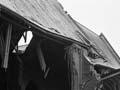
In 1942 a chain of earthquakes hit Wairarapa. The first jolt was on the morning of 24 June, followed by a 7.2 magnitude tremor that evening. Centred near Masterton, the earthquake triggered landslides, damaged buildings, and toppled chimneys as far away as Wellington. An estimated 4,700 Wairarapa chimneys came down. In early August the earth moved again, demolishing many rebuilt chimneys. Some fell again in a final shake in mid-December.
Climate
Partially sheltered by the Tararua Range, Wairarapa has a dry, warm climate. It receives between 800 and 1,200 millimetres of rain each year, with western areas wetter than the east. Masterton’s annual sunshine hours average just under 2,000.
Summer weather is warm, dry and mostly settled. Typical maximum daytime temperatures range between 20 and 28°C, sometimes rising above 30°C. Winters are cool to mild, but frosts are common. Maximum winter temperatures are usually between 10 and 15°C.
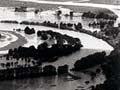
Strong north-west föhn winds can occur in spring and summer. These gather strength as they come down the Tararua Range, and can reach 170 kilometres per hour at Castlepoint. Wairarapa is exposed to heavy rain from the south and east, which can cause flooding.