Tephra is a general term for all the fragmental material erupted explosively from a volcano – ranging from fine dust (called ash) to car-size blocks. It is a Greek word meaning 'ashes', originally used by Aristotle to describe a volcanic eruption in the Aeolian Islands near Sicily, in the fourth century BCE.
Layers in the landscape
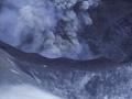
North Island volcanoes have blasted huge volumes of tephra into the air, to be blown over northern New Zealand and in some cases far out to sea, for more than 1,000 kilometres. This volcanism has deposited layer upon layer of tephras over the landscape. The layers have helped volcanologists work out the history of volcanoes and the distribution of their far-reaching airborne products.
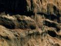
In many parts of the North Island, natural cliffs along terraces, river banks or at the coast, together with cuttings made during road construction or quarrying, reveal blanketing layers of tephra fallout from numerous eruptions. They drape the landscape on which they fall, generally following the contours of hills, terraces and valleys.
Tephra as a dating tool
Tephra-fallout layers have two special features:
- They are erupted over a very short time, geologically speaking, usually a matter of only hours or days to a few weeks.
- They can be spread widely over land and sea to form a thin blanket that has the same age wherever it occurs.
Once identified by geochemical analysis, a tephra layer provides a marker bed for an ‘instant’ in time, that instant being the time of eruption that produced the layer. In New Zealand and elsewhere many studies have used tephra layers as a dating tool, a science called tephrochronology.
Fingerprinting tephras
How can one tephra layer be distinguished from another? Scientists use many methods to characterise or fingerprint each layer, both in the landscape and laboratory.
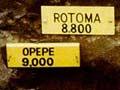
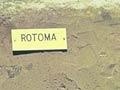
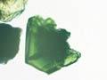
In the landscape, colour, thickness and position of the tephra in the sequence are important, and sometimes the type of pumice is useful in identifying it. For example, pumice from the Taupō eruption (about 232 CE) is usually cream-coloured and easy to crush, whereas pumice from the Kaharoa eruption (about 1314 CE) is white and hard to crush.
Changing thickness
A tephra layer from a single eruption may be tens of metres thick near its source and coarse grained, but over 100 kilometres away it thins rapidly to only a few centimetres or millimetres of fine ash.
In the laboratory, the types of mineral grains (crystals) sometimes allow the tephra to be identified and matched to a source volcano. For example, a widespread tephra erupted from the Tūhua caldera (Mayor Island) about 7,000 years ago contains very unusual minerals. This tephra can be identified instantly with a microscope, even from just a few grains. Chemical analysis of volcanic glass in tephra layers is the most useful way of fingerprinting them.
Distribution of tephras in New Zealand
The thickest tephra sections occur downwind of the Taupō Volcanic Zone, but much of the central part of the North Island has a tephra mantle up to several metres thick immediately beneath the land surface. Because of this, many North Island soils have been derived from tephra deposits rather than the underlying bedrock.
Some of the most complete tephra sequences have been found in lakes and bogs. Thin layers only a few millimetres thick may be preserved, whereas they are rapidly eroded on dry land. For example, cores from lakes near Hamilton revealed at least 46 tephra layers 2 to 120 millimetres thick, from seven North Island volcanoes (Taupō, Okataina, Tūhua, Taranaki, Tongariro, Ngāuruhoe and Ruapehu) over the last 20,000 years.
Similar studies from Auckland showed that scores of thin tephras from the same North Island volcanoes, including at least 43 tephras from Taranaki volcano, have rained out over the area for more than 70,000 years. Older tephra deposits, many metres thick, strongly weathered and clay-rich in many places, also occur in both these areas.
Volcanic topdressing
The frequent eruptions from the volcanoes of Tongariro National Park, and Taranaki have added small amounts of many nutrients to soils downwind. For example, the 1995–96 Ruapehu eruptions added up to 1,500 kilograms per hectare of sulphur and other elements to large areas of land in the central North Island. Volcanic topdressing and a favourable climate is the reason why top-class carrots are grown at Ohakune.
Tephra on the sea floor
The longest and most complete tephra records have been obtained from deep-sea drilling. Recently, 134 tephra layers, one nearly 1 metre thick, were found in cores from Leg 181 of the international Ocean Drilling Programme, around 700 kilometres east of the North Island. The layers record repeated large explosive eruptions from the Coromandel volcanic zone (Coromandel Peninsula–Tauranga area) from 2 to 12 million years ago, and then in the Taupō Volcanic Zone from about 2 million years ago.