
Nearly one million hectares of land – much of it within existing reserves – are classified as ‘specially protected areas’. This extra level of protection may be given because of the area’s significance for biodiversity, wilderness recreation, cultural reasons, or its vulnerability to human impact.
There are seven types of specially protected areas:
- national park specially protected areas
- sanctuary areas
- ecological areas
- wilderness areas
- wildlife refuges and sanctuaries
- tōpuni
- nohoanga.
Areas of high conservation value, such as national park specially protected areas, sanctuary areas and wildlife refuges, often have access restrictions and permit requirements. Similar conditions apply to nature and scientific reserves because they are the most important (and vulnerable) reserves.
National park specially protected areas
There are only a few specially protected areas within national parks. They include Slip Stream in Mount Aspiring National Park, a site of great cultural significance to the Ngāi Tahu tribe. The 51,800-hectare Special Takahē Area, covering the Murchison Mountains in Fiordland National Park, protects the endangered takahē.
Sanctuary areas
Sanctuary areas are also limited in number and distribution. Most were set aside by the former New Zealand Forest Service as a result of conservation activism in the 1970s and 1980s. They preserve important forest types, such as the magnificent kauri forest remnants in Northland. The 9,105-hectare Waipoua Forest Sanctuary, containing Tāne Mahuta and other giant kauri, was the first to be created, in 1952. One of the more recent is Whirinaki Sanctuary, created in the 1980s to protect the podocarp forests of Whirinaki Forest Park.
Ecological areas
Ecological areas are usually large (1,000–5,000 hectares) and are representative of all the main ecosystems in a defined ecological district. Like sanctuary areas, most were designated by the Forest Service as a result of forest conservation controversies in the 1970s and 1980s. Most are on the West Coast of the South Island, and in Southland and Bay of Plenty. The public can access them, but dogs are prohibited.
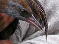
Wildlife refuges and sanctuaries
Wildlife refuges and sanctuaries protect particular species in an area. For example, the Moutohorā Island Wildlife Refuge in Bay of Plenty is notable for its breeding colony of grey-faced petrels. It is also home to many other bird species, including North Island saddlebacks (tīeke).
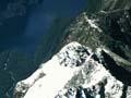
Wilderness areas
Wilderness areas are large areas (usually more than 40,000 hectares) of natural wild land. They are open to the public but do not have visitor facilities such as huts, tracks and bridges. To protect their natural quiet and solitude, vehicles and aircraft are prohibited.
Wilderness areas lie in the more remote, mountainous parts of the country, and offer opportunities for self-reliant recreation. Typical examples are Raukūmara Wilderness Area, around the Mōtū River and the Raukūmara Range inland from East Cape, and Tasman Wilderness Area in the Tasman Mountains of Kahurangi National Park.
Tōpuni
Tōpuni are South Island areas specially protected by Ngāi Tahu because of their significance to the tribe. The word tōpuni means ‘to cover’ – referring to the custom where a person of high rank claimed authority over areas or people by laying a cloak over them. The best known tōpuni covers Aoraki/Mt Cook, in Aoraki/Mount Cook National Park.
Nohoanga
Nohoanga are Māori seasonal occupation sites, usually on lake shores or river banks, where fish and other resources were traditionally harvested. They are usually no bigger than 1 hectare, and are located so as not to interfere with public access or use. As Treaty of Waitangi claims are settled, more nohoanga are likely to be created.
Making private land public
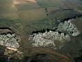
The Queen Elizabeth II National Trust was set up in 1977 to encourage landowners to protect features of great beauty or interest through legal covenants. Most covenanted areas are not open to the public, but a few owners have made them available for everyone to visit and enjoy. Examples are Aroha Island in the Bay of Islands, the Pouawa dune lands at Gisborne, the top of Tākaka Hill near Nelson, and Clay Cliffs in the Mackenzie basin.
Private protected areas
Over 100,000 hectares of private land has been protected through systems including management agreements and conservation covenants (usually for areas no larger than 100 hectares). A further 73,000 hectares of private land is voluntarily protected by owners through covenants or agreements with the Queen Elizabeth II National Trust.
A special fund, Ngā Whenua Rāhui, was set up in 1991 to encourage voluntary preservation of ecosystems on Māori land. The Māori owners retain tino rangatiratanga (ownership and control). The Minister of Conservation has approved over 95 proposals, covering 112,000 hectares.