Image
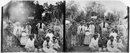
This group at Pokeno, photographed between 1861 and 1863, are thought to be objecting to a survey to establish the line of the Great South Road from Auckland into Waikato, which was seen by Māori as a threat to their sovereignty. Blocking the path of the surveyors was one tactic; others included the removal of survey pegs and surveyors’ tools.
Te whakamahi i tēnei tūemi
Alexander Turnbull Library, Urquhart Album (PA1-q-250)
Reference: PA1-q-250-27-2
by William Temple
Permission of the Alexander Turnbull Library, National Library of New Zealand, Te Puna Mātauranga o Aotearoa, must be obtained before any re-use of this image.