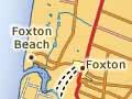


Foxton
Town 39 km south-west of Palmerston North and 20 km north of Levin, with a 2013 population of 2,643 (and 1,641 at adjacent Foxton Beach).
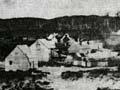
It began as the Māori settlement of Te Awahou, on the Manawatū River estuary. After the 1855 earthquake Pākehā settlers abandoned Paiaka, upriver, and moved to Foxton. The settlement was also a base for Presbyterian James Duncan’s missionary work. The 1866–67 New Zealand Almanac recorded five storekeepers, three bootmakers, two carpenters, a hotel keeper, a ferryman, a road overseer, four surveyors, nine farmers and four labourers in the town of Manawatū, named after the river.
The settlement was renamed Foxton in honour of Premier William Fox. It thrived on the flax boom of 1869–70 and then as the gateway to the newly opened upper Manawatū. The first pile of Foxton wharf was driven in February 1873, and the Manawatu Herald began publication in 1878. A new courthouse and post office brought the official stamp of approval.
Economic ups and downs
Foxton lost ground to Palmerston North. ‘If a spark of jealousy does ever brighten up their contented dullness’, wrote one correspondent in 1873, ‘it is caused by the aspiring little inland township of Palmerston some twenty-five miles distant.’ 1 In 1886 Palmerston North gained the extra advantage of the Wellington–Manawatū railway link.
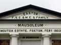
Flax booms in 1888–89, and from 1898 to 1919, brought much activity. Still, by 1935 only three of the town’s 11 flax mills were left. Ships last called at the port in 1941, and the railway closed in 1959. The river was redirected by the Whirokino cut in 1942. After the Second World War a carpet factory opened, and more recently chicken processing has provided many jobs. It is also feasible to work in Palmerston North (30 minutes away) and Levin (15 minutes). The town has many museums, cafés and other attractions for travellers on State Highway 1. In 2017, the $8.6 million Te Awahou Nieuwe Stroom complex combining Dutch and Māori culture opened. Two marae of the Ngāti Raukawa tribe, Motuiti and Paranui, are just north of the town.
Manawatū and Horowhenua coasts
Interrupted only by river outlets, the region’s sweep of beach was the major communication route north and south until the Wellington–Manawatū railway was completed in 1886. In colonial times ferries operated on the main rivers, or travellers moved upstream to where horses and coaches could cross.
Behind the beach are enormous stretches of sand dunes, which quickly spread inland when the native plant cover was removed. In the 20th century, plantations of pine and marram grass have stabilised the dunes. But the coastline continues to advance. In the 1970s, the shipwreck of the Hydrabad (1878) at Waitārere was below the high-water line. Today the tide seldom reaches it, and it is mostly buried in the sand.
Himatangi murders
On Paranui Road between Himatangi and Rangiotu, a farmhouse burnt to the ground on the night of 6 September 1929. Police found the charred bones of seven occupants, and later it was established that all eight people living in the house had died. ‘What was left of their bodies’, the Manawatu Times reported, ‘could have been packed in a portmanteau’. No arrests were ever made in the case, and in Manawatū ‘they still talk about the Himatangi tragedy’, wrote Monte Holcroft in 1972. 2
Beach settlements
Tangimoana, Hīmatangi Beach, Foxton Beach, Hōkio and Waikawa are all coastal settlements at river or stream outlets (another settlement, Waitārere, is an exception). Tāngimoana is also the site of a government intelligence-gathering installation (a second is at Waihopai in Marlborough). The settlements are generally free of the upscale development of resorts such as Taupō and Queenstown. Mostly used by Manawatū and Horowhenua locals, the houses have the informal and often exuberant architecture that is the hallmark of the New Zealand bach or beach house.