

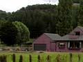
Kimbolton and environs
Kimbolton is the largest centre in the former Kiwitea county. This occupied the north-west part of Manawatū, between the Rangitīkei and Ōroua rivers. In 2013 this district had a population of 1,443.
The Beaconsfield ballot
Beaconsfield's historian, Dorothy Pilkington, writes of an auction for township sections held on 30 November 1877. Prospective buyers were lubricated by a champagne lunch, after which lots covering about 7 acres (3 hectares) were sold, for up to £18 per acre for a corner section. But the town never developed. A high cliff by the Kiwitea stream was an unwelcome feature of the planned main street. Most town sections eventually became part of farms.
It is mostly rolling country. The fertile flat land on the Cheltenham–Kimbolton highway is called Ram Alley because of the number of pedigree sheep raised there. In earlier times the district was thickly forested, and only occasionally visited by Māori. The Crown purchased the land in 1866 and 1877. Beaconsfield was opened for settlement in 1876, Rewa and Waituna West from 1880, and Kimbolton (initially called Birmingham), Ōtamakapua and Rangiwāhia from 1886.
Across the Ōroua River, the Āpiti flats were also settled in 1886, but a bridge over the deeply incised river was only completed in 1896. Since the pioneering days the districts have generally thrived on pastoral farming. But from the 1980s the relatively small population dwindled, as people had easier access to town (Feilding) and local businesses, post offices and the school closed.
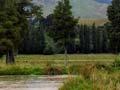
No wine in the wetlands
Retiring Massey University wine microbiologist Gordon Pilone reckons that Manawatū is too wet for grapes. He has planted kahikatea trees and developed a wetland on his Pohangina property. In his spare time he dabbles in another hobby – a grass-topping business for lifestyle blocks.
Pohangina
Valley and adjacent hill country north-east of Palmerston North, with a 2013 district population of 1,095. It lies between the southern Ruahine Range and the ridge separating the Pohangina and Ōroua catchments. Māori trapped eels and birds there, but probably did not permanently settle except near Ashhurst, where the Pohangina and Manawatū rivers join.
European settlement began in the late 1870s and moved up the valley as sawmillers advanced in front of farmers. The population reached a peak in 1906, when sawmilling was at its height and before roads made it easier to reach larger centres. A remnant of the tōtara forest that once covered the river flats and terraces lies north of Pohangina township. The character and beauty of the valley have lured a number of ‘lifestylers’ in recent years.