Alpine landslides
In alpine terrain made up of hard rock and steep, high slopes, landslides range from huge rock avalanches that can shape mountain peaks and travel several kilometres in minutes, to massive rock slides, rock falls and debris flows.
It can be difficult to distinguish between rock avalanches, and ice or snow avalanches. Most avalanches originate as falling snow or ice, which can include rock and other debris. Avalanches of rock can also pick up ice and snow. The avalanches mentioned here originate as falling rock and are characterised by rapid, turbulent movement.
How are the mighty fallen
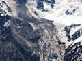
The Aoraki/Mt Cook rock avalanche of 14 December 1991 was a classic example of an alpine landslide. Twelve million cubic metres of the east face of the mountain dropped away, lowering the summit by 10 metres.
In volcanic mountains, a debris flow known as a lahar can be generated from rapidly melting snow or a crater lake bursting. This highly charged flow of sediment and water can carry large blocks at high speed for many kilometres down a river bed.
Many alpine landslides are considered catastrophic because of their volume, speed and distance. In populated mountain regions of the world, they are responsible for widespread death and destruction. New Zealand’s mountain lands are largely uninhabited except for a few tourist locations, and so represent more of a potential hazard than a current threat.
Low mountain landslides
In lower mountain ranges and hard-rock hill country, a range of landslides from small wedge failures to large, deep-seated rotational and planar slides occur. Some are instantaneous, while others move gradually over long periods.
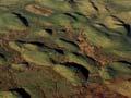
In Central Otago the Cromwell Gorge landslides, investigated during the construction of the Clyde dam in the 1980s, were slow moving, causing the hill slope to sag. Such processes are often controlled by structures within the rock, and by the rate at which rivers are eroding the base of the slope. While these landslides are not an immediate threat to life, they are long-lived and can gradually destroy roads and structures, and block rivers.
Layered rock landslides
Layered rock landslides are controlled by the way different rock types rest on each other and their direction and degree of tilting. The geological conditions that lead to this sort of landslide are widespread throughout New Zealand.
Commonly, a hard, permeable rock (such as sandstone, limestone or volcanic rock) rests on a softer rock such as mudstone. In these circumstances the weight of the overlying rock cap, together with a build-up of groundwater under it, causes the softer rock to lose its strength and deform. (Think of a custard square with the pastry crust being the upper rock and the custard as the deformed mudstone beneath.)
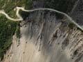
Consequently, the hard rock cap slides over the soft rock, or the underlying rock fails, leading to a collapse of the hard rock cap. An example of this is the Abbotsford landslide disaster, which destroyed 69 houses in a suburb south-west of Dunedin on 8 August 1979. Many such landslides were first recognised and described in detail from the Dunedin district in 1940 by the pioneering work of the geologist Noel Benson.