
Kōrero: Landslides

Abbotsford landslide

Image
Abbotsford landslide

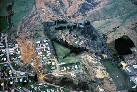
New Zealand’s most publicised landslide occurred in the Dunedin suburb of Abbotsford. Cracks were first noticed by residents in 1969. In May 1979 an underground water pipe was unearthed and engineers noted that ground movement had caused it to split. Large cracks soon appeared in the earth. On 8 August the slope failed. The homes in the centre of the photo slid from left to right, carrying 17 people with them. Luckily no one was injured.

Te whakamahi i tēnei tūemi

GNS Science

Reference: SL47/44

by Lloyd Homer

Permission of GNS Science must be obtained before any use of this image.

Ngā whakaahua me ngā rauemi katoa o tēnei kōrero

Me pēnei te tohu i te whārang

Michael J. Crozier, Landslides – Alpine, low mountain and layered rock landslides, Te Ara – the Encyclopedia of New Zealand, https://teara.govt.nz/mi/photograph/8790/abbotsford-landslide (accessed 4 June 2026).

He kōrero nā Michael J. Crozier, i tāngia i te 2 March 2009, updated 19 February 2026.

Comments

rhian
24 April 2014
The landslide occurred in Abbotsford Dunedin. The landslide had started like a decade before but was moving very slowly creating cracks in the concrete but the major movement didn’t happen till shortly before 9pm on the 8th of august 1979 after a heavy fall of rain and snow it moved at extreme pace making it the biggest in New Zealand.