
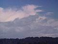
Wind and rain
New Zealand’s prevailing winds are westerlies, which pick up moisture as they blow across the Tasman Sea. As they rise over the mountain ranges that stretch from the centre of the North Island to the far south, they drop rain on the western region, particularly in the South Island. Curling around in the far south across Stewart Island and Southland, the winds create a wet, mild, cloudy environment. Western New Zealand has the highest and most consistent year-round rainfall in the country.
Constant cloudiness moderates the cooler winters of the south, but it also means the summers are not reliably warm.
Landforms
The western sides of the Southern Alps were covered in glaciers during ice ages. Eroded peaks, glacier-sculpted valleys, loops of moraine (glacier-carried rocks and debris, often enclosing lakes) and outwash plains such as the Mackenzie Basin are common in the South Island.
In the lower North Island, vigorous river action and erosion during ice ages created terraces and fertile plains topped with loess (wind-blown dust).
Rapid uplift of the mountains has created distinctive sea-cut terraces in places from Taranaki to the far south of Fiordland. On the Manawatū plains, sand dunes have penetrated far inland from the coast, creating ridges, hollows, and chains of lakes.
Vegetation
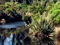
The western lowlands are often dominated by tall forests of rimu and kahikatea. Beneath are kāmahi, Quintinia acutifolia, rātā and tree-fern canopies, with abundant climbers and broad-leaved understorey shrubs and small trees.
Rivers bring silt down to the floodplains, forming fertile soils where swampy kahikatea, flax and cabbage trees grow. Mataī and tōtara stands grow on better drained soils. Terraces and poorly drained plateaus typically have deeply leached, low-nutrient soils, with rimu forests and low forest of silver and pink pine.
In many places rushlands and mānuka scrub grow on open, wet, nutrient-poor sites. Along the shores, the mild coastal climate and persistent cloudiness allow frost-tender species such as the nīkau palm and supplejack vine to grow far south.
Diverse environments
North-west Nelson has lower uplift rates than the mountains further south, and has large outcrops of granite, marble, and limestone. Beech-clad mountains and isolated alpine areas have led to considerable diversity in plants and invertebrates (animals without backbones).
In Fiordland, in the far south, similar rocks and lower tectonic activity have also fostered many unique plant and animal species.
Stewart Island is unusual in that, unlike other southern districts, it lacks beech forest – it is covered in dense, conifer–broadleaf forest. With its cool, moist, cloudy climate and peaty soils, it forms a link to the subantarctic islands.
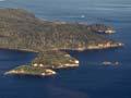
Marlborough Sounds
The Marlborough Sounds in the north-east of the South Island are deeply indented with drowned valleys and islands, formed by a sinking landscape and rising sea levels at the end of the last glaciation.
The scatter of small islands was once connected to the mainland by low sea levels during the last glaciation. They are now predator-free havens for a number of species, including the lizard-like tuatara and the giant wētā.
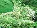
Beech forest grows on the weathered uplands, in low-nutrient soils. Below this is coastal broadleaf bush, with warm temperate species such as nīkau, tawa and toatoa.
On D’Urville Island, on patches of toxicity in fertile soil, forest has been replaced by low-growing shrubs and grasses.
The far south
Southern Fiordland, Stewart Island, the Catlins region of Southland, and the subantarctic islands all have mild winters and cool summers.
Plants include silver beech (absent on Stewart Island), kāmahi, rātā, rimu and miro. There are also some large-leaved southern island species such as Olearia lyallii and the spectacular megaherb Stilbocarpa lyallii.
Eastern Southland is not as wet as districts further west. It still has a reliable, evenly distributed rainfall, mild winters and cool summers because of its exposure to regular south-westerly weather. Its rolling, fertile landscape is covered with loess (fine windblown dust). It was once clad with tall conifer–broadleaf forest, but this is now mostly restricted to hilly or mountainous regions.
Bogs, covered with wirerush (Empodisma minus) and mānuka, are a spectacular feature of the river plains, now much reduced by peat mining and drainage.