What is an ecoregion?
An ecoregion (shorthand for ecological region) is a geographical area. It is defined by features such as climate and soil, which lead to varied plant and animal communities. Ecoregions are a way of mapping areas on an ecological rather than political basis. This enables land managers and conservationists to better understand the areas they manage.
New Zealand’s diverse environments
With its outlying islands, the New Zealand region extends from the subtropical zone in the north (including the Kermadec Islands) to the subantarctic in the south (Campbell Island). Within this national region there are many distinctive areas. This is the result of several factors:
- a north-south orientation, the three main islands spanning latitudes 34° to 47° south
- diverse geology
- mountainous terrain
- a persistent, moist, westerly windflow.
Methods of classification
There are several methods of classifying ecoregions in New Zealand, from broad to highly detailed. One classification, based on climate, geology and soil, divides the country into 20 regions (based on 800 distinctive environments). Another widely used classification recognises 85 ecological regions and 286 ecological districts.
Nine ecoregions
The ecoregions identified here are broad: six on the mainland and three offshore island regions. They are classified according to climate, geology, landforms and plant cover.
- The northern islands
- The northern North Island
- The Volcanic Plateau
- The Southern Alps and other axial ranges
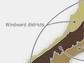
- Windward districts (exposed to westerlies)
- Leeward districts (protected from westerlies)
- Central Otago
- Chatham Islands
- The southern islands
Climate
The distinctive character of life forms in the different regions is due in large part to variations in climate. The north has a warm, moist subtropical climate, while the south is cool and moist. Prevailing westerly winds drop rain on the western coasts as they rise over the main mountain chain. The eastern districts are warmer and drier.
Thoughts of home
Aware of New Zealand’s diversity, journalist Alan Mulgan commented in his autobiography, ‘To a South Islander, New Zealand may suggest first, tussock land and Alps. To me it is primarily an Auckland tidal harbour and a clay cutting near the sea on a hot day, with accompaniment by cicadas.’ 1
Geology
The meeting of the Pacific and Australian tectonic plates has created an unstable, fault-splintered zone in central and south-western New Zealand, producing high mountains and a complex range-and-basin topography.
The far north and far south-east of the two main islands of New Zealand are more tectonically stable than much of the country in between. The typical landscape is low, rolling hills.
The small, scattered island groups to the north and south are mainly remnants of basaltic volcanoes. They are important for their marine birds and mammals, and unique land species.