
Glaciers and rivers
A central spine of mountains extends from the volcanic plateau in the North Island down to Fiordland. It forms the western boundary of this ecoregion.
Extensive faulting and recent uplift have created parallel lines of young mountains to the east, from Gisborne down to central Canterbury. The mountains consist mainly of greywacke, with extensive limestone and mudstone, especially in Hawke’s Bay and North Canterbury.
Glaciers caused vigorous erosion on the eastern slopes of the mountains. Long, braided rivers have built wide alluvial fans at the foot of the mountains.
Along the eastern slopes of the Southern Alps are a set of spectacular glacial valleys with deep lakes dammed by moraines (ridges of debris carried by glaciers). Fed by the glaciers, braided rivers formed impressive gravel and silt terraces. Wind-blown dust (loess) from the rivers has coated much of the eastern leeward district, and accelerated erosion in the mountains has created deep alluvial plains of gravel and silt.
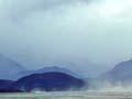
Eastern regions: dry and sunny
The western mountains intercept the prevailing rain-bearing westerly winds. This creates a rain shadow (an area of reduced rainfall on the leeward side). The climate is much drier and less cloudy than in western areas.
In summer, drought and dry soils are widespread, with frosty, sunny conditions in winter. The low rainfall means fewer nutrients are leached from the soil, which is among the most fertile in the country.
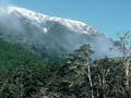
Original vegetation
The lowlands were once covered by conifer forests, dominated by tall mataī, tōtara and miro on well-drained sites and kahikatea on swamplands. Only on the wetter flanks of inland ranges did more moisture-loving trees such as rimu, silver beech, rātā and kāmahi dominate.
Human impact: forest to tussock
In prehistoric times these eastern regions seem to have been the most productive area for moa. Vast moa-bone deposits have been found in swamps and early Māori hunting sites.
Because of low rainfall and frequent drought, the southern zone of this region was largely deforested by Māori fires. Remaining eastern forests in the North Island did not long survive European settlement. As a result, the native plants of eastern areas are now mainly short or tall tussock, mānuka and kānuka.
Māori fires created vast areas of bracken and scrub landscape in the north, and bracken, scrub and tussock covered the landscape in the south. Most of this has since been developed for pasture or forestry although in the inland South Island much pastoral tussock country remains.