Monitoring earthquakes – GeoNet
New Zealand has a national network of instruments and data centres, GeoNet, which detects and monitors earthquakes, volcanic activity, large landslides, tsunamis and the slow deformation that precedes large earthquakes. Data from instrument stations throughout the country is transmitted via satellite, radio and computer links to centres at Wairākei and Wellington, which are operated by GNS Science. GeoNet’s computers automatically analyse any earthquakes above a given magnitude and post the information on their website. This website has become New Zealand’s primary source of immediate information when people feel an earthquake. GeoNet staff can provide information to help emergency services respond rapidly, and high-quality data is freely available to researchers. GeoNet centres routinely locate more than 20,000 earthquakes per year. The year 2016 was exceptional, however, with 32,828 quakes recorded due to numerous aftershocks from several major earthquakes.
Can earthquakes be predicted?
New Zealand scientists have found that some large earthquakes may be preceded by distinctive changes in the pattern of smaller ones over several years. However, it is not yet possible to predict where and when earthquakes will strike, or their likely magnitude.
Some areas of New Zealand have a higher probability than others of damage from earthquakes. The frequency of large earthquakes can be estimated from historical records of earthquakes since European settlement, from geological evidence of past large earthquakes, and from instrumental records of smaller quakes.
Geological studies provide evidence of the timing and size of past earthquakes. By examining faults where they cut the surface and digging trenches through them, scientists can determine when these last ruptured and how frequently they moved in prehistoric times. As earthquakes commonly recur along faults, their history may indicate their likely future behaviour.
Additional information about possible future earthquakes comes from measuring land movement in areas that are being deformed, using techniques such as Global Positioning System (GPS) measurements and radar. This information can be used to identify areas where the likelihood of earthquakes is increased or reduced.
Reading the signs
Accurately predicting ‘the big one’ remains a conundrum for scientists. Over the centuries, many signs of an impending earthquake have been proposed. Animals are thought to behave strangely – sheep and cattle were restless 15 minutes before the 1968 Īnangahua earthquake. Unusual lights in the sky have preceded some earthquakes. These may be related to changes in the ground’s electrical conductivity. But the claim that earthquakes are preceded by ‘earthquake weather’ – sultry, ominous conditions – is unproven, as no direct correlation has been found between weather conditions and seismic activity.
Short-term warnings
Earthquake swarms or foreshocks have heralded some earthquakes, including the 1888 North Canterbury, 1929 Murchison and 1987 Edgecumbe quakes. In the weeks before the North Canterbury and Murchison earthquakes, people reported booming noises – small earthquakes that were heard rather than felt. More often, however, powerful earthquakes have struck with little warning, or even following a quiet period.
The ability to accurately predict an impending earthquake could result in life-saving measures, including evacuation of a region. But the social and economic cost could be high if the prediction proved to be wrong. The ultimate goal of prediction is to save lives and minimise damage, disruption and the cost of recovery. As yet there is no sound scientific basis for earthquake prediction, so communities in regions with a high likelihood of earthquakes must be prepared, by designing earthquake-resistant buildings and structures, planning for civil defence and educating the public on emergency measures.
Earthquake insurance
New Zealand is one of the few countries in the world with national government earthquake insurance for homeowners. In 1944, two years after earthquakes seriously affected Wairarapa and Wellington, a national commission was set up to cover damage from earthquakes. Cover for landslides, tsunamis, volcanic eruptions and hydrothermal activity was added later. In 1993, war damage was excluded and the commission became the Earthquake Commission (EQC). EQC insurance covered homes and their contents up to a specified monetary limit, but not commercial properties or motor vehicles. Homeowners automatically got EQC cover when they bought fire insurance.
EQC was renamed Natural Hazards Commission Toka Tū Ake on 1 July 2024. It maintains a natural disaster fund, invested both in New Zealand and overseas, and buys catastrophe reinsurance. Natural Hazards Commission provides core funding for the GeoNet monitoring network, and funds hazard research and public education programmes.
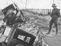
Disaster response
Traditionally the response to disasters such as earthquakes was the responsibility of local communities, with assistance from the government on a case-by-case basis. The scale of the 1931 Hawke’s Bay earthquake showed the need for a national response to disasters as well as for public education.
A national emergency management system gradually evolved after the Second World War. The current system is based on a network of emergency response teams in regional centres, with a core of trained staff and volunteers, co-ordinated by the National Emergency Management Agency.