
Lake Taupō
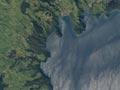
At 623 sq km, Lake Taupō is New Zealand’s largest volcano and its largest lake. It occupies much of the caldera (volcanic depression) formed by massive eruptions between 50,000 and 22,000 years ago. The most recent eruption was about 232 CE. Between 60 and 100 cubic km of ash and rocks were ejected near the Horomatangi reefs, which lie underwater near Waitahanui (south of Taupō town). Nearby cliffs mark the caldera edge, while other parts of the lake’s shoreline are the result of faulting.
The lake is named for the ancestor Tia’s rain cloak (taupō) – the full name is Te Taupō-nui-a-Tia. It is also sometimes called Taupō moana (Taupō sea).
Hot swim, cold swim
At many places on Lake Taupō’s shores, steam seeps to the surface to heat the shallow water. A few metres out, the cold lake water seems icy in contrast.
Ngāti Tūwharetoa have long held mana over the lake and its surroundings. Europeans first saw the lake in the 1830s, but few stayed, as the area was isolated and not suited to farming. Trout were introduced at the start of the 20th century, and in later decades the lake has been used for many kinds of water sports, including yachting, waterskiing and power boating. In 1992 the ownership of the lake bed was returned to Ngāti Tūwharetoa, and a new regime was set up to manage the fisheries of the lake and its tributaries.
Western Bay
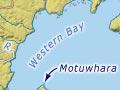
The north-western part of Lake Taupō and the western part of the main Taupō caldera. The bay is the least settled part of the lake, but is popular with recreational fishers, who mostly come by boat from Taupō or Kinloch. The Karangahape Cliffs, part of the caldera rim, are a striking feature. The tiny island of Motuwhara is just offshore.
Kinloch
Settlement and marina 23 km north-west of Taupō town, on the shores of Whangamatā Bay. Kinloch was laid out by Prime Minister Keith Holyoake and his family, who farmed in the district from 1962. There are contemporary Māori rock carvings on a cliff face at Kaiapo Bay, between Kinloch and Taupō.
Waitahanui
Township 12 km south of Taupō town on State Highway 1. Waitahanui is a long-established Māori settlement, with a Ngāti Tūtemohuta marae. Nearby Lake Rotongaio is the site of many important events in Tūwharetoa tribal history.
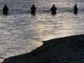
Waitahanui is also renowned for its trout fishing, in the Waitahanui Stream and particularly in the ‘rip’, where the stream waters mingle with the lake. The ‘picket fence’ of fly fishers in chest-high waders is a common sight at dawn and dusk, when the trout feed.
Hātepe to Motuoapa
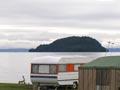
A chain of holiday settlements, with houses, motor camps, motels and campsites, are found on the lake’s south-eastern corner between State Highway 1 and the shore. From the north they are Hātepe, Jellicoe Point, Motutere, Waiteteko, Te Rangiita, Oruatua, and Motuoapa. The settlements are only partly occupied for most of the year, but the population expands in summer. As its name suggests, the Motuoapa (island of Apa) peninsula was once an island – it is now joined to the mainland by accretion.
Motutāiko, offshore from Hātepe, is a true island. The white pumice cliffs north of Hātepe, where the western side of the Taupō caldera meets a fault line, can be seen from many kilometres away. There are marae at Waiteteko and Te Rangiita.