Rerewhakaaitu
Lake and farming district on the edge of the Rotorua lakes volcanic area. The road names of Republican, Democrat and Yankee recall the US troops who trained in the area during the Second World War. They left traces for years after – in two months of 1957–58, more than 40 live shells were detonated by the army. Many farms in the area were allocated to servicemen who had returned from the Second World War, and the community hall dates from 1958.
Horohoro and Guthrie
Farming districts 15 and 18 km south-west of Rotorua, developed between the two world wars.
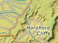
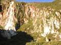
Horohoro was one of the first areas in native minister Apirana Ngata’s land development scheme, which established farms on Māori land from 1929. The Rongomaipapa marae was built by Ngāti Kahungunu migrants from Wairoa, who came to the area as part of the project. Kearoa marae is named after the wife of Te Arawa ancestor Ngātoroirangi. Horohoro’s full name is Te horohoro-o-ngā-ringaringa-a-Tia – the place where the ancestor Tia washed his hands and ended a tapu (spiritual restriction). Fault movement has produced the striking bluffs of the Horohoro cliffs, an outlying part of the Mamaku Plateau. The Treetops luxury lodge backs onto the bluff’s stands of rimu and tawa.
Guthrie was named after D. H. Guthrie, a 1920s minister of lands.
Ngākuru and Waikite Valley
Tranquil farming localities south of Rotorua, between State Highways 5 and 30. Ngākuru was developed from the late 1920s, and its hall was built in 1945.
Waikite Valley was developed after the Second World War. Its school opened in 1955, and the hall in 1957.
Waiotapu
Thermal area and farm settlement 23 km south of Rotorua. Waiotapu has New Zealand’s largest area of surface thermal activity. Features include the Lady Knox Geyser, the multicoloured silica terraces known as the Artist’s Palette, the Bridal Veil Falls and the Champagne Pool. Nearby Rainbow Mountain has colourful and steaming volcanic rock.
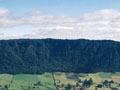
Paeroa Range
Visible from State Highway 5 and Waikite Valley, the Paeroa Range rises sharply on its western side. Produced by fault movement, it has dissected ridges on the east. The range’s summits – just under 1,000 metres high – are covered in forest, and some are included in Te Kopia scenic reserve.
Conscientious objectors’ camp
Much of the government-owned Strathmore estate near Reporoa was sold as farm blocks in 1938. During the Second World War, conscientious objectors, including the artist and art critic Rodney Kennedy, were held in a detention camp on the unsold part of the estate.
Reporoa
Township and district 39 km south of Rotorua and 43 km north of Taupō, between the Paeroa Range and the Kāingaroa plateau. The town’s population was 453 in 2013. The nearby marae is Matarae.
The region was originally swampy – Reporoa means ‘long swamp’. W. P. Butcher was reputedly the first European settler, in 1894. Reporoa developed after the Second World War, once problems with bush sickness (a wasting disease of stock) were overcome. The road names Alamein, Casino [sic], Anzio and Sangro are reminders of Second World War battles. Most farms run dairy cattle, and milk is processed at a factory on State Highway 5.
Broadlands
District and locality 33 km north-east of Taupō and 8 km south of Reporoa. It was named by Auckland businessman Edward Earle Vaile, who bought 21,500 hectares of land in 1907 and wrote about the district’s settlement in Pioneering the pumice (1939). Broadlands Road is a favoured shortcut between Taupō and Rotorua.