

Taupō
The North Island’s most recent urban centre, Taupō is 84 km south of Rotorua, 360 km north of Wellington and 205 km south of Auckland. In 2013 its population was 21,864.
Early days
Taupō’s urban history can be dated to the establishment of an armed constabulary post in 1868 – a time when the government sought to strengthen its lines of communication in the central North Island. The Spa and Terraces hotels were opened close to hot water pools and springs. From the early 20th century the township provided accommodation for anglers fishing for trout in the lake and nearby rivers.
Expansion
A road board was established in 1922, a town board in 1946, and a borough in 1953. In 1956 Taupō’s population was just 2,849. It grew rapidly thereafter, as tourism, timber and farming expanded. Many private holiday houses were built, as well as motels and short-term accommodation – the largest cluster in the North Island outside Rotorua.
Downtown street names – Paora Hapi, Tamamutu, Te Heuheu and Horomatangi – commemorate Ngāti Tūwharetoa notables. Rifle Range Road is a reminder of the early armed constabulary presence.
Town clerk in Taupō
Sam Torepe was Taupō’s town clerk (chief executive officer) from 1950 to 1956. He was believed to be the first Māori town clerk in New Zealand.
Taupō today
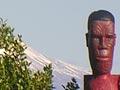
In the 1980s Taupō acquired a museum, concert centre and indoor sports arena. Since 2009 a number of sculptures have been installed in the town. Subdivisions have seen the town spread along both sides of Tapuaeharuru Bay. Taupō draws many athletes to compete in the Ironman New Zealand triathlon, the Lake Taupō Cycle Challenge and other competitions.
Although Taupō is closer to Auckland than Wellington, it has traditionally attracted most of its domestic visitors from the lower North Island. The winter view across the lake to the snow-clad summits of Tongariro, Ngāuruhoe and Ruapehu is one of the most photographed in the country.
Nukuhau
Māori settlement across the Waikato River from downtown Taupō. Nukuhau dates back to before the town of Taupō was founded. It was the home of the late-19th-century chief Poihipi, and is the site of one of the town’s two marae. The other is at Waipāhīhī, where State Highways 1 and 5, the routes to Wellington and Napier respectively, diverge.
Acacia Bay
Suburban neighbourhood across Tapuaeharuru Bay to the west of Taupō town. Acacia Bay was first laid out for housing in the 1950s. In 2013 it had a population of 1,425, but the numbers are much greater in summer. The Tauhara retreat and conference centre is located behind the settlement.
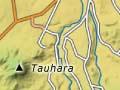
Tauhara
1,088-metre volcanic peak rising above Taupō. Its summit, accessible by a walking track, provides an excellent view over the Volcanic Plateau – including Mts Tarawera and Edgecumbe (Pūtauaki) in the far north, the Kāingaroa plateau to the north and east, and Lake Taupō and the central volcanoes to the south. In Māori tradition, Tauhara was a suitor of Pīhanga, but lost her to Tongariro.