Oruanui
Locality 21 km north-west of Taupō, a sawmilling area from 1898. The district was witness to massive fires in February 1946 which left the country ‘black and lifeless’. Te Kapa o Te Rangiita marae lies on the west side of the road. The 1911 St Matthew’s Church, decorated throughout with woven tukutuku panels, is on the east.
21st-century Māori
The Tuaropaki Māori Trust at Mōkai owns much of the surrounding farmland, a glasshouse operation with Gourmet Paprika Ltd, and a 55-megawatt geothermal power station, the operation of which is contracted to the Mighty River Power company.
Mōkai
Locality 29 km north-west of Taupō, also known as Tuaropaki, Mōkai flourished from 1898 as a sawmilling town at the end of a private railway from Putaruru, completed in 1905. Today the forest, the rail track and most of the town are gone. The Pakaketaiari marae has splendid carvings, impressive painted maihi (bargeboards), and a war memorial in its grounds.
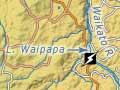
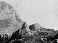
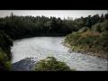
Ātiamuri
Lake and hydroelectric power station, on the Waikato River and State Highway 1, 39 km north-west of Taupō and 25 km south-east of Tokoroa. The name Ātiamuri (Tia who follows behind) commemorates Te Arawa ancestor Tia, who reached the place after others. Ngāutuku, a rock outcrop rising 240 metres above the Waikato River, figures in the traditions of the Te Arawa and Ngāti Raukawa tribes.
The dam and 84-megawatt power station were built between 1953 and 1958. A small settlement survives at Ātiamuri – mostly holiday and retirement houses.
Whakamaru
Lake, locality and power station on the Waikato River. The settlement and power station are at the western end of Lake Whakamaru, 10 km south-east of Mangakino. The former New Zealand Electricity Department hydro settlement, its houses now privately owned, is a short distance from the junction of State Highways 30 and 32. The power station was completed in 1956 and has a capacity of 100 megawatts.
Mangakino
Former hydroelectricity town on the Waikato River, 35 km south-west of Tokoroa. The district was settled by Ngāti Kahungunu from Wairarapa after the First World War, who received land in part exchange for gifting the Wairarapa lakes to the Crown. Mangakino was built in the 1940s to house the dam builders, including those at nearby Maraetai. In 1956 the town had a population of 4,456 – larger than Taupō. The 2013 population of 744 was less than half that of 1996, but the 2013 unemployment rate was 12.9%, a big drop from the 2001 rate of 21.4%. Properties were originally on leasehold land, but are now freehold, so the town attracts second-house owners.
Hauhungaroa Range
Greywacke range that abuts the Taupō and Tongariro section of the Volcanic Plateau. Peaks include Tītīraupenga (1,042 metres), Pureora (1,165 metres), Weraroa (1,091 metres), Tuhingamata (883 metres) and Hauhungaroa (1,078 metres).
From the 1930s to the 1970s a sawmill operated at Tīhoi, 60 kilometres west of Taupō. Today it is the site of an outdoor education school. In the 1970s, the forest around Pureora was the scene of protests by conservationists opposed to logging of native forest. Pureora Forest Park contains one of the North Island’s largest tracts of unfelled native forest outside the main ranges, and the rich bird life includes the rare kōkako.