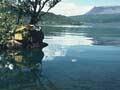
Lake Tarawera
The largest of the lakes in the Okataina caldera, Lake Tarawera was formed about 5,000 years ago when drainage to the east was blocked by lava flows. Holiday houses line the only road, along the western side of the lake. Elsewhere, bush reaches the shore.
Blackberries, grey mountain
Author Robin Hyde wrote of picking blackberries near Te Wairoa in 1927. ‘[N]ot far away are the skeleton remains of wrecked huts, stranded articles of furniture – casualties of Mount Tarawera’s awful day of volcanic wrath. Like a grey ghost the deadly mountain, its rent craters still plain on its denuded sides, stands bare amid the rich wooded purple of friendlier Rotorua hills.’ 1
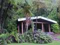
The small settlements of Te Wairoa and Punaromia are on the road from Rotorua, shortly before it reaches the lake. Near Te Wairoa is the ‘buried village’ – the earlier settlement which was smothered under nearly 2.5 metres of ash, mud and debris in the 1886 Tarawera eruption. The excavated site is open to visitors, and includes a museum.
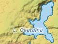
Lake Okataina
Lake east of Rotorua city, 33 km away via the road to its northern end. Lake Okataina’s full name, Te Moana-i-kataina-ā-Te Rangitakaroro, refers to Te Arawa ancestor Te Rangitakaroro. The lake was formed about 7,000 years ago, and is essentially a moat between the wall of the Okataina caldera and the Haroharo volcanic complex (a volcanic area similar to Mt Tarawera, but lower).
Ngāti Tarāwhai had a marae at Te Koutū and gifted the shores of the lake to the Crown in 1921. Ngāti Rongomai has associations with the west side of the lake. A road reaches the lake from the north, but other than that, the shores are bush-clad, and the solitude and beauty attract anglers and walkers. Lake Okataina drains via underground seepage to Lake Tarawera, from which it is separated by a narrow neck of land.
Lake Okareka
Small volcanic lake on the western side of the Okataina caldera, 10 km east of Rotorua city. There are a number of holiday houses, on the western shore in particular. Well-known Auckland families such as the Winstones and the Caugheys are among those with places on the ‘millionaire’s miles’ of Acacia and Summit roads.
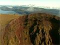
Mt Tarawera
Volcanic mountain rising nearly 800 metres above the level of adjacent Lake Tarawera, to 1,111 metres. Tarawera comprises a series of domes, formed when rhyolite, and sometimes basalt, were ejected. One eruption 42,000 years ago threw out 50 cubic kilometres of rhyolite.
Mt Tarawera’s June 1886 eruption produced a series of craters along the ridge of the Wāhanga, Ruawāhia and Tarawera peaks, and south-west through Lake Rotomahana. The mountain belongs to the Tūhourangi people, and the summit can be reached by road with permission from the owners.
Lake Rotomahana
A crater lake, previously the site of the famed Pink and White Terraces (in Māori, Te Otukapuarangi and Te Tarata). Lake Rotomahana is part of the volcanic fissure – almost 16 kilometres long – which erupted on 10 June 1886 along with Mt Tarawera. The eruption destroyed the terraces and emptied the lake, which was then much smaller. The depression later filled with water, forming a larger Lake Rotomahana.
The eruption also created the Waimangu geothermal field. When the Waimangu geyser was active, from 1900 to 1904, it was the largest in the world, sometimes reaching almost 500 metres.
Green and blue waters
Lake Rotokākahi (Green Lake) looks green from the air because is shallow and has a sandy bottom. Tikitapu (Blue Lake) gets its blue colour from reflection from the white rhyolite and pumice lake bed.
Lake Rotokākahi (Green Lake) and Tikitapu (Blue Lake)
Two volcanic lakes, south-east of Rotorua city on the road to Lake Tarawera. Rotokākahi is much larger than Tikitapu, and the colour distinction between the two is most marked on a fine day. Kākahi is a freshwater shellfish, and Tikitapu means ‘sacred being’. Rotokākahi is owned by the Tūhourangi and Ngāti Wāhiao people.