
Banks Peninsula
Mass of volcanic hills (1,165 sq km) jutting from the Canterbury coast between Pegasus Bay and the Canterbury Bight. The highest point, Mt Herbert (Te Ahu Patiki, 920 m), overlooks Lyttelton Harbour. It is less than half the height of the volcanoes before they became extinct.
The hilly terrain, wetter climate and history of podocarp forest clearance make it more typical of parts of the North Island than of Canterbury. The hills are farmed, but tourism now has more economic importance. Cheese was one of the first products exported from Banks Peninsula (to Australia) and a small cheese factory remains at Barrys Bay. Akaroa is the principal town. Other small settlements are connected by steep, narrow roads.
Island or peninsula?
In 1809 the vessel Pegasus surveyed the South Island east coast. At that time the most definitive map of New Zealand was that of James Cook, who had identified Banks Island (named after Joseph Banks, a botanist sailing with him). But when Captain S. Chase of the Pegasus tried to sail between Banks Island and the mainland he discovered the ‘island’ was in fact a peninsula.
Little River
Settlement about 25 km west of Akaroa. A coaching stop on the route to Akaroa, and the terminus of a branch railway from 1886 until 1962, Little River developed as a sawmilling settlement, supplying timber to Christchurch. It is now a farm service town which also caters to travellers to Akaroa. The railway station is now a shop and visitor centre. Some residents commute into Christchurch. Wairewa (Lake Forsyth) meets the sea at Birdlings Flat, a small beach settlement with a few permanent residents.
Akaroa
Township 84 km south-east of Christchurch and about 25 km east of Little River. The resident population – 624 in 2013 – is stationary, and more than 60% of the dwellings are holiday homes. The town sits on the eastern side of the splendid harbour from which it takes its name.
Canterbury’s oldest town, Akaroa was founded in August 1840 by French settlers. It has been suggested that French interest in New Zealand speeded up Britain’s decision to annex New Zealand. By the time French settlers arrived, the Treaty of Waitangi between the British Crown and Māori chiefs had been signed.
Akaroa has a fine collection of 19th-century cottages and houses. The French associations are evident in street names. Once a fishing and farm service town, it now serves mainly holidaymakers and tourists. It has become a popular port of call for cruise ships, with 90 visits scheduled during the 2019/20 season.
About 5 km south is a small Māori settlement, Ōnuku, with a historic church and modern meeting house.
Wainui
Scattered collection of holiday homes on the opposite side of Akaroa Harbour from the town of Akaroa. The road to Wainui passes through French Farm, where for a few years in the 1840s, the French navy had a presence.
Peraki Bay
Remote bay south of Akaroa, now inhabited by a few farming families. The first permanent settlement of Europeans in Canterbury was the shore whaling station established in 1837 there by Captain Hempelman. A monument marks the spot.
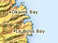
Le Bons Bay
Farming locality 11 km north-east of Akaroa, first settled by the French. For many years the only access was by boat. The remains of the jetty can still be seen.
Okains Bay
The largest of the Peninsula’s eastern bays, 20 km north-east of Akaroa. It supports a number of farms. The Okains Bay Māori and Colonial Museum has an important collection of Māori and early European artefacts, and a meeting house.
Little Akaloa
Farming settlement and bay 25 km north of Akaroa. The bay provides shelter for small boats.
Pigeon Bay
Bay 20 km north-west of Akaroa. It was settled in the 1840s, before Christchurch was founded, by the Hay and Sinclair families. The village at its head survives as a cluster of houses and holiday homes.
Port Levy
Locality (sometimes known as Koukourarata) 14 km south-east of Lyttelton. It was the site of a large Māori reserve in the 19th century, and still has quite a high Māori population. Monuments mark important sites in the introduction of Christianity to the South Island.