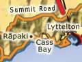

Lyttelton
Town picturesquely sited on the steep sides of an extinct volcano, above the port at Lyttelton Harbour. It is 12 km south-east of Cathedral Square in central Christchurch, via the road tunnel through the Port Hills, opened in 1964. In 2013 Lyttelton had 2,859 residents, many of whom commute to Christchurch to work.
In 1850 Lyttelton was a town of about 300 when the site of Christchurch was still bare plain, but Christchurch overtook it during the 1850s. The town’s role as the region’s port was assured with the opening of a rail tunnel in 1867.
The Lyttelton Harbour Board (1877), now Port Lyttelton Company, developed the inner harbour. Large reclamations, for petroleum storage tanks in the 1920s and the Cashin Quay container berth in 1965, ensured the port’s importance. A new container terminal was opened in 1977.
Lyttelton was close to the epicentre of the magnitude 6.3 earthquake that devastated Christchurch on 22 February 2011. Many Lyttelton buildings were destroyed in the quake. They included Holy Trinity Church (Canterbury's oldest stone church), the Harbour Light Theatre, the Empire Hotel and the historic Timeball Station, which had been damaged in the Darfield quake. The Timeball tower was rebuilt and reopened in November 2018.
Godley Head
Locality on the north side of the Lyttelton Harbour entrance, named after John Robert Godley, the founder of the Canterbury settlement. It became a military reserve in 1851. An 1865 lighthouse was relocated down the cliff face in 1942 when coastal defence works were built. Department of Conservation notices give information about the Second World War gun emplacements there. As a farm park, it is a popular recreation area.
Rāpaki
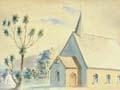
Village 5 km west of Lyttelton. When land was being set aside for Ngāi Tahu after the land purchases of the mid-19th century, a reserve was created at Rāpaki. There has been a Māori village there ever since. Rāpaki’s historic buildings include a church, a school for Māori pupils and a meeting house. Above Rāpaki, the peak Te Poho o Tamatea recalls the visit of the great navigator Tamatea Pōkai Whenua on the Tākitimu canoe.
Governors Bay
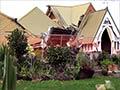
Small settlement near the head of Lyttelton Harbour, with access to Christchurch over Dyers Pass. The residents (870 in 2013) are mostly commuters. The village grew in the early days of English settlement, and significant historic buildings include St Cuthbert’s Church (1860–62) and the Ohinetahi Homestead (1864), which has one of New Zealand’s finest formal gardens. Both were restored after being seriously damaged in the September 2010 earthquake.
Grey’s greeting point
Governors Bay takes its name from one of New Zealand’s best-remembered governors, George Grey. It was here that he waited on board HMS Fly to welcome the first Canterbury Association settlers on their arrival in December 1850.
Quail Island
Island at the head of Lyttelton Harbour. From the 1880s it was a quarantine station, for people and then animals. In 1901 and 1910, the island housed dogs and ponies destined for British Antarctic expeditions. Between 1918 and 1925 it was a leper station. Now a reserve, it is being replanted with native vegetation.
Charteris Bay
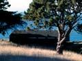
Farming locality 5 km by boat south from Lyttelton. It is the site of Orton Bradley Park, named after the son of an early settler who gave the family farm to the people of Canterbury. Farm buildings include an 1848 cottage and a working, water-powered machine shed. There are fine plantings of exotic trees.
Diamond Harbour
Suburb of Lyttelton on the sunny south side of Lyttelton Harbour. Diamond Harbour is the fastest growing community on Banks Peninsula. Its population and that of Charteris Bay and Pūrau grew from 879 in 1991 to 1,467 in 2013. Still standing are the original cottage and later homestead of Mark Stoddart, the early settler who named the bay for the glint of sunlight on water.
Pūrau
Township at the head of Pūrau Bay, 2 km south-east of Diamond Harbour. In 1853–55 Robert Rhodes, from a notable early Canterbury family, built a substantial stone homestead, which still stands. The bay is a popular picnic and camping spot.
Rīpapa Island
Island just off the southern shoreline of Lyttelton Harbour. Its substantial ‘musket pā’ was obliterated when Fort Jervois was built (1885–1895) for coastal defence. The island had served as a quarantine station between 1873 and 1885.