Conway River
Short river that forms part of the northern boundary of the Canterbury region. It drains hill country south of the Kaikōura Ranges and enters the sea at Conway Flat.
Parnassus
Settlement 14 km north of Cheviot and 65 km south-west of Kaikōura. It takes its name from a local sheep run owned by a classical scholar, Edward Lee. He saw a likeness between a local hill and the Greek Mt Parnassus, mythical home of the god Apollo and the Muses.
Parnassus was the railhead for the main line north from 1912 until rail construction resumed almost 30 years later. It declined from 1980 when a new road north of the Waiau road bridge diverted traffic from the township.
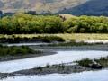
Waiau River
A 169-km river that rises in the Spenser Mountains and flows across three intermontane basins – the Hanmer Plain, the Amuri Plain and the Cheviot Basin. Between these basins and the sea, the river flows through gorges. On the Amuri Plain, some of its water is tapped for a major irrigation scheme.
A road beside one of its tributaries, the Leader River, connects Parnassus with Waiau in the Amuri district. This road was on several occasions used by traffic between Kaikōura and Christchurch when floodwaters threatened the old bridge across the Waiau River.
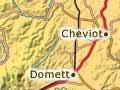
Cheviot
Small rural service township 115 km north-east of Christchurch and 14 km south of Parnassus on State Highway 1. Its 2013 population was 375.
Local hero
The purchase of large pastoral runs by the Liberal government in the 1890s allowed people of modest means to get into farming. The government, and especially the minister of lands, John McKenzie, gained enormous popularity as a result. The town of Cheviot was originally named McKenzie, and the street names commemorate Liberal politicians.
The township began in the late 19th century after the subdivision of the 33,600-hectare Cheviot Hills run. This was named after the range of hills on the border between Scotland and England. Owned by William ‘Ready Money’ Robinson, it was one of Canterbury’s largest 19th-century properties. In 1892–93 the government purchased it and subdivided it into small farms – a landmark event in the breaking up of large estates. In the Cheviot Hills Domain are the foundations of Robinson’s Mansion House, which burned down in 1936.
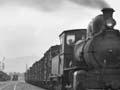
Domett
Settlement 8 km south-west of Cheviot. Like Cheviot, it developed after the 1893 subdivision of the Cheviot Hills run. It became the railhead of the main trunk line in 1907, and the station is now a tourist stop. It continued to thrive after the railway continued north, but as roads were improved, its local service role diminished.
Gore Bay
Beach resort 8 km south-east of Cheviot. Until the railway reached Domett in 1907, goods for Cheviot came and went by sea, initially using surfboats at Gore Bay. In 1879 William Robinson of Cheviot Hills built a slipway and shed at Port Robinson, 4 km to the south, where ships could anchor in the lee of a headland, to be serviced by a boat worked from the slipway. There is still a slipway at Port Robinson.
Hurunui River
A 138-km river that rises on Harper Pass. Its north branch flows through Lake Sumner. In its middle reaches it crosses the Amuri district. The historic Hurunui Hotel is on the river’s south bank by the State Highway 7 bridge. Close to the river’s mouth is a settlement of fishing huts and holiday homes.