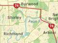

East Christchurch, especially the low-lying areas close to the lower reaches of the Avon River, was the part of suburban Christchurch most severely affected by the earthquake of 22 February 2011. There was considerable liquefaction and damage to the foundations of buildings, and much land on both sides of the river was declared a red zone unsuitable for construction. Residences in this zone were removed or demolished.
Burwood
Suburb near the lower reaches of the Avon River. Burwood was the site of a plague hospital built at Bottle Lake in 1902. Now Burwood Hospital, it specialises in treating burns and spinal injuries. In the north-east of the suburb was Queen Elizabeth II Park, a 25,000-seat stadium built for the 1974 Commonwealth Games. It was so badly affected by the earthquake that use of the park was abandoned.
Richmond
Suburb between central Christchurch and Shirley. Known originally as Bingsland, it had working-class houses, small shops and artisans’ workshops. Liquefaction and land movement were extensive in the eastern part of Richmond in the Canterbury earthquakes. Land along the river was red-zoned, and considerable depopulation followed. Some older gentrified houses were lost.
Shirley
Suburb north and east of Richmond. Shirley developed somewhat later, gaining large tracts of inter-war bungalows. A major shopping centre, The Palms, is at the intersection of Shirley, New Brighton and Marshland roads. It was damaged in the earthquakes and closed for six months. North of Shirley, the Marshland district has been a major source of vegetables and fruit for Christchurch, but subdivisions are encroaching on market gardens.
Aranui
Working-class suburb north of the Estuary, originally a small village around tram lines running to New Brighton. Many state houses were built there after the Second World War. Bexley, on the north side of Aranui, was the suburb most affected by the earthquakes, with most of the land red-zoned, requiring the removal or demolition of extensive recently built housing.
Bromley
Suburb south-west of Aranui. Between 1958 and 1962, sewage treatment works were built where a sewage farm had been established in 1882–83. There are oxidation ponds and the Te Huingi Manu wildlife refuge. There is also a crematorium and four cemeteries – Bromley, Ruru Lawn Cemetery, Memorial Park and Linwood. It is the site of engineering works and a number of housing estates.
New Brighton
Seaside suburb on the sandy beach of Pegasus Bay. In 1894 New Brighton gained a pier, like Brighton in England. This was demolished in 1965, but there is a concrete replacement (opened in 1997). From 1887, trams brought city folk to the beach. New Brighton and the area was governed by its own borough council from 1896 until 1941.
Seaside shopping
For a time from 1946 New Brighton was the only place in New Zealand where shops were allowed to open on Saturdays (they were closed on Mondays). People flocked to the coastal suburb on their day off, but once Saturday trading began nationwide in the 1980s, business dropped off markedly.
From the 1950s houses spread south down the Brighton Spit. North of New Brighton, North Beach had its own tram and trolley bus lines into the city. The suburb of Parklands has grown as land has been subdivided. The Canterbury earthquakes took a toll on New Brighton's commercial centre, with the loss of eight buildings, mostly south of the mall, and a decline in population in neighbouring red-zoned suburbs.
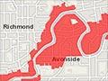
Linwood
Large working-class and lower middle-class eastern suburb. Linwood was one of the independent boroughs that in 1903 became part of Christchurch City. Linwood Avenue was the line of a planned canal between the estuary and the Avon River, but this was never built. The large Eastgate shopping mall at the intersection of Linwood Avenue and Buckleys Road was damaged in the February 2011 earthquake and substantially closed until September 2011. Linwood also lost two Victorian buildings: Holy Trinity Church and Linwood House. Falling rolls and damage led to the merging of two pairs of primary schools and the closing of the intermediate school. Houses were damaged, but few were demolished.
North of Linwood in Avonside all the housing along the river was red-zoned, while to the south in Phillipstown Jade Stadium was condemned and is being demolished.
The Estuary
Tidal body of water, separated from Pegasus Bay by the South New Brighton sand spit. The waters of the Avon and Heathcote rivers mingle in the Estuary to flow out to sea past Shag Rock. Until the Lyttelton rail tunnel was opened in 1867, small ships passed through to wharves on the Heathcote and Avon, bringing heavy goods from Lyttelton. A sewage treatment works (with large oxidation ponds that form an important wildlife refuge) replaced the old sewage farm on the north side in 1962.