


Glimpsed from the sea
Abel Tasman’s first view of New Zealand on 13 December 1642 was from off the West Coast. He described ‘a large land, uplifted high’ – the Southern Alps, or perhaps the Paparoa Range. James Cook had a similar view in 1770. For both explorers the weather was poor, so they stayed well out to sea and were able to do little more than sketch in the coastline and mountain peaks. They could tell that the land was forest-covered and the coastline lacked sheltered anchorages. Appropriately, one of the few West Coast features named by Cook was Cape Foulwind.
First European exploration
Although most of the North Island and the eastern side of the South Island had been explored by the mid-1840s, the West Coast had hardly been visited by Europeans, apart from a few sealing parties. It was known to be forest-covered and mountainous, with high rainfall, so seemed unattractive for immediate settlement.
The search for land suitable for farming close to the Nelson area led to three major exploring expeditions between 1846 and 1848 by Thomas Brunner and Kehu (a Māori guide), accompanied by Charles Heaphy on the first two trips. They traced the Buller River from its source to the sea, traversed the Grey and Īnangahua valleys, and explored and mapped the coastline as far south as the mouth of the Paringa River.
Exhausted and unwell at the end of his final trip, Brunner concluded that there was no worthwhile land on the West Coast. Until 1857 there was little European interest in the region.
Land purchase and settlement
In the late 1850s a shortage of agricultural land in Canterbury and Nelson led to renewed interest in the West Coast. Before Europeans could settle on the land, it was necessary to come to an agreement with the Māori occupants, Poutini Ngāi Tahu.
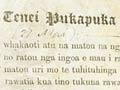
A smudged deed
After the Arahura Deed was signed, it was accidentally immersed in the Grey (Māwhera) River when James Mackay upset his canoe. Although the signatures are clear, some of the writing is smudged. Legend has it that Mackay was reprimanded for not taking better care of such an important document.
In 1859 James Mackay was instructed by the government to purchase the land. After detailed negotiations, the Arahura Deed was signed by leading Poutini Ngāi Tahu chiefs on 21 May 1860. The whole of the West Coast region, apart from small areas reserved for local Māori, was sold to the Crown for £300 (about $36,000 in 2019 terms). One of the reserved areas was the settlement of Māwhera, part of the present town of Greymouth.
The lure of gold
In November 1859, surveyor John Rochfort found gold in several places on the West Coast, including the Taramakau valley and lower Buller Gorge. Over the next four years a trickle of prospectors explored parts of the West Coast, but there were no major gold finds. At the end of 1863 the total population (Māori and Pākehā) was probably less than 300. The Otago goldfield (discovered in 1861) seemed more attractive, and as that declined there was a rush to Wakamarina (Marlborough) in early 1864.
Hokitika booms
Geologist Julius Haast was astonished at how quickly Hokitika had expanded when he visited in April 1865. He recorded, ‘The principal street, half a mile long, consisted already of a large numbers of hotels, banks and dwelling-houses, and appeared as a scene of almost indescribable bustle and activity … there was shouting and bell-ringing, deafening to the passers-by; criers at every corner of the principal streets which were filled with people – a scene I had never before witnessed in New Zealand.’ 1
Gold rushes
The discovery of payable quantities of alluvial gold in Greenstone Creek near Hokitika in mid-1864 led to a major gold rush. The time was right – floods and poor returns at Wakamarina had left prospectors ready for new fields. By late 1864 further discoveries had been made near Hokitika, and the population had swelled to over 1,000.
With a succession of gold discoveries in different parts of the West Coast through 1865 and 1866, the population exploded, peaking at about 28,700 in late 1867. In only three turbulent years the main towns had been laid out.