
Taranaki is a geologically young region, dominated by Taranaki Maunga (Mt Taranaki), a dormant 2,518-metre volcano.
Taranaki Basin
The Taranaki Basin is a large, sinking block, formed by movement between the Australian and Pacific tectonic plates. Over the past 80 to 100 million years, rocks eroded from the surrounding land have been deposited in the basin as mudstone and sandstone, up to 7 kilometres deep in places. These sediments are still being deposited, although the shape of the land has changed dramatically over time.
Taranakite
The mineral taranakite was discovered by Henry Richmond, superintendent of Taranaki, in crevices at Sugar Loaf Point in New Plymouth. It was described by government geologist James Hector during the 1865 Dunedin exhibition after being presented by Richmond. With an impressive chemical formula of KAl3(PO4)3(OH)9H2O, taranakite is a hydrated phosphate of potassium and aluminium, derived from bird guano deposited on aluminium-rich rocks in damp conditions.
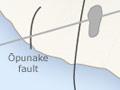
Within the basin, a large block of crust has dropped down between the Taranaki Fault in the east and the offshore Cape Egmont Fault in the west, forming the Taranaki graben. Many of Taranaki’s oil and gas fields are found along these two main faults.
The mudstones (papa) of the Taranaki Basin are largely covered by volcanic debris in the west. To the east they form the deeply dissected hill country of inland Taranaki.
Coastal terraces
For a few kilometres inland in the north and south of the region there are fertile coastal terraces with sandy soils.
Fossil fauna
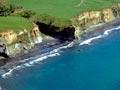
The Tangahoe Formation mudstones, exposed in the cliffs of South Taranaki, were formed in the Pliocene period, between 2 and 5 million years ago. Palaeontologist Joseph McKee recovered a remarkable range of marine fossils from the mudstones. They include a 10–12-metre-long shark (Carcharodon megalodon),whales, dolphins, penguins and seals, as well as fragments of Pseudodontornis, a huge seabird with a 6-metre wingspan and bony, tooth-like projections on its beak.
Volcanic sequence
Taranaki is one of New Zealand’s major volcanic regions. Over the past 20 million years a series of eruptive centres have progressively moved south.
Around 15 million years ago, a number of underwater volcanoes erupted off the coast of northern Taranaki and Waikato. These long-extinct volcanoes are now buried deep below the sea floor.
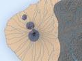
Paritutū
Paritutū and the Sugar Loaf Islands (Ngā Motu), off the coast of New Plymouth, are the 1.75-million-year-old eroded remnants of Taranaki’s first onshore volcano. Paritutū is thought to be the plug of lava from the cone.
Kaitake
The next oldest volcano is centred on Kaitake, about 15 kilometres south-west of New Plymouth. It was active around 575,000 years ago, and was probably once as big as Taranaki Maunga. Erosion has reduced it to a range of hills only 680 metres high.
Pouākai
Pouākai, due south of New Plymouth, first erupted about 670,000 years ago and was strongly active about 250,000 years ago. Geologists believe this volcano was eventually about 2,000 metres high. Most of its extensive ring plain of ash and lahars (avalanches of mud and rock) has been buried by the later activity of Taranaki Maunga, but to the north are deeply eroded remnants of Pouākai’s immense debris flows.
Egmont volcano – first cones
Geologically, Taranaki Maunga consists of two eruptive centres, Egmont volcano and Fanthams Peak. Their complex history is still being unravelled.
Activity at Egmont volcano began over 125,000 years ago, building a cone which collapsed about 105,000 years ago (Ōkawa Formation).
Another cone then formed before collapsing about 50,000 years ago (Stratford Formation). Later, a third peak suffered two major collapses. The first, 27,000 years ago, flowed south-east (Ngaere Formation), and the second, 23,000 years ago (Pungarehu Formation), slid westward in a massive avalanche. This lahar covers more than 250 square kilometres and is up to 20 metres deep, forming thousands of small hills inland from Cape Egmont.
Drowned forests
At Waitara, and at Wai-iti beach near Urenui, stumps and logs from former forests are visible at low tide. The tree stumps at Wai-iti are fossilised remnants of a tōtara forest killed by a rise in sea level about 7,000 years ago. Tree trunks on the beach at Airedale Reef, Waitara, are the remains of a forest destroyed by a debris avalanche from an early Egmont volcano about 105,000 years ago.
Fanthams Peak and present Egmont cone
Fanthams Peak (Panitahi), on the southern slopes of Egmont volcano, was last active around 3,000 years ago. The present upper Egmont cone was built by eruptions over the last 4,000 years.
Around 1500 CE, several extremely hot clouds of ash exploded from the crater and destroyed much of the forest on the north-western slopes. About 150 years later, a pumice shower buried a Māori campsite near the present-day Stratford Mountain House. The last known eruption, the Tahurangi Ash, was around 1755, although a 2007 study suggested there was activity in the crater area in the 19th century.
Waterways
There are 286 main river catchment areas and 530 named rivers in Taranaki. The ring plain around Taranaki Maunga is crossed by many rivers and streams which run down to the lowlands in a radial pattern. The longest is the Pātea River. The Waitara River and many tributaries of the Pātea rise in the eastern hill country. Man-made Lake Rotorangi on the Pātea River is the largest lake. It is 46 kilometres long and up to 65 metres deep, and covers 6.45 square kilometres.
Climate
On the west coast of the North Island, Taranaki is exposed to prevailing weather systems from the Tasman Sea. It is usually sunny (averaging 2,200 hours annually at New Plymouth) and windy, with year-round rainfall and moderate temperatures. Annual rainfall ranges from 8,000 mm at North Egmont to 2,000 mm at inland Whangamōmona, 1,400 mm at New Plymouth and 1,200 mm at Pātea. Taranaki Maunga has a rain-shadow effect, with less rain to its south and east.
In the early 21st century, intensified dairying and horticulture was putting pressure on the water table.