
Kōrero: Waikato tribes

Taupiri

Image
Taupiri mountain

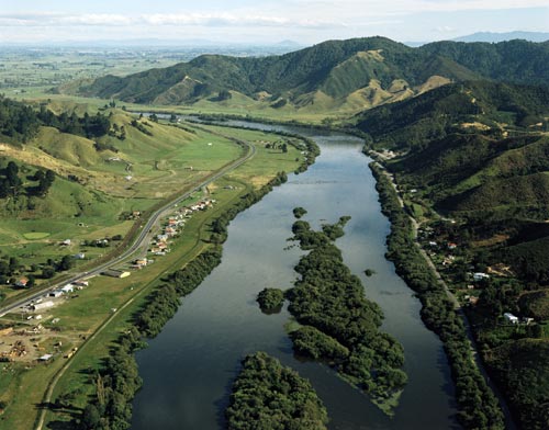
Ko te awa o Waikato tēnei, ko Taupiri kei te taha mauī, i te piko o te awa.

Ko Taupiri te maunga tapu o ngā iwi o Waikato. Anei te pepeha:

Ko Taupiri te Maunga
Ko Waikato te Awa
Ko Te Wherowhero te Tangata.

Ko Taupiri te takotoranga whakamutunga o ngā rangatira o Waikato, tae atu ki te kāhui ariki.

Te whakamahi i tēnei tūemi

GNS Science

Reference: 513/15

by Lloyd Homer

Permission of GNS Science must be obtained before any use of this image.

Ngā whakaahua me ngā rauemi katoa o tēnei kōrero

Me pēnei te tohu i te whārang

Te Ahukaramū Charles Royal, Waikato tribes – The Waikato confederation, Te Ara – the Encyclopedia of New Zealand, https://teara.govt.nz/mi/photograph/1711/taupiri (accessed 25 June 2026).

He kōrero nā Te Ahukaramū Charles Royal, i tāngia i te 4 March 2009, updated 1 March 2017.

Comments

Ted Turua ngataki
23 March 2021
Ko taku tupuna noa Te ngeangea me Puhirawaho.noa Matakino ,noa Mitai Ngataki
SHARNAYAR
06 November 2012
WOW LOVE TAUPRIR MOUNTAIN DNT HATE ON IT COZ UE WIL GET WATS COMING
Merimeri Anania
08 July 2012
About 5-6 years ago I had already informed the photographer of this particular article about the mistake. I live in Taupiri and like yourself Graham, know that this picture does not show Taupiri mountain but is of the south of Huntly, going towards Taupiri along SH1. I did get a response from the photographer who from memory, thanked me for the correction but could not remove the picture for some reason.
PJ
14 July 2011
My thoughts also Graham. Found that picture rather confusing. Thanks for clearing that up.
Graham Ralls
01 January 2011
Taupiri Mountain does not appear in this photograph at all. I live 5km south of the mountain, and this view appears to be looking south from above Huntly, and the bend in the river is the next bend downstream from Taupiri Mountain, as the river flows north towards you. In other words Taupiri Mountain is further to the left than this photograph allows, around the bend in the river until the river takes another bend to the right (out of picture top left).