Image
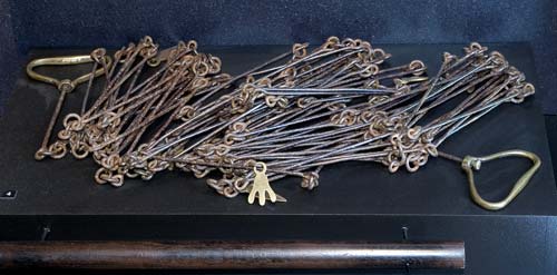
This survey chain belonged to Frederic Carrington, who laid out the site of New Plymouth in the early 1840s. Survey chains were used to measure distances. They consisted of 100 iron links and were one of many pieces of equipment early surveyors had to carry with them. A ‘chain’ became a standard unit of measure (66 feet or 20.12 metres) in Britain, Australia and New Zealand.
Te whakamahi i tēnei tūemi
Puke Ariki - Taranaki Museum & Library
Reference: A77.364
This item must not be copied or reproduced in any print or electronic media without the prior permission of Puke Ariki Museum and Library. It is the responsibility of the user of any material to obtain clearance from the copyright holder.