Image
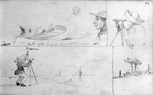
Walter Mantell drew these sketches during his 1848 journey from Kaiapoi to Dunedin. Mantell was responsible for setting aside reserves of land for the Ngāi Tahu tribe within the recently purchased Canterbury block. Clockwise from top left: a squashed hat; either Mantell or his assistant Malmanche looking through a theodolite; a Māori food storage platform; two men taking bearings across a river, with a theodolite.
Te whakamahi i tēnei tūemi
Reference: E-334-089
by Walter Baldock Durrant Mantell
Permission of the Alexander Turnbull Library, National Library of New Zealand, Te Puna Mātauranga o Aotearoa, must be obtained before any re-use of this image.