New Zealand is a nation of islands. The mainland is flanked by more than 600 smaller islands that lie within about 50 kilometres of the coast. (There are also more distant groups, officially called offshore islands – the Kermadecs, the Chathams and the subantarctic islands.)
Islands near the North Island
Most of New Zealand’s nearshore islands lie near the North Island, between North Cape and East Cape. They include:
- the relatively remote Three Kings group, 53 kilometres north of Cape Rēinga
- the 150 islands of the Bay of Islands
- 47 islands in the Hauraki Gulf Maritime Park. These include the Poor Knights (Tawhiti Rahi and Aorangi) and the Hen and Chickens (Taranga and Marotiri); Great Barrier Island (Aotea, the largest); Kawau Island; the island suburb of Waiheke; and the volcanic cone of Rangitoto Island.
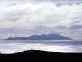
- a small number of volcanic islands off the Bay of Plenty coast, including Whakaari (White Island) and Tūhua (Mayor Island).
Around the lower North Island there are few islands. The largest is Kāpiti Island, north-west of Wellington.
Islands near the South Island
In the South Island there are three major clusters.
- The Marlborough Sounds is a maze of drowned river valleys and hilly islands, including D’Urville Island, the largest in the area.
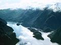
- Fiordland’s islands were also created by rising seas. Some, such as 211-square-kilometre Resolution Island, are areas of Fiordland mountains isolated by fiords.
- Stewart Island (Rakiura) is surrounded by small islands, and the Rakiura National Park includes 170 islands and rock stacks.
Drowned valleys
The topography and geology of islands vary enormously, from low islands barely above the high tide mark to rugged mountain blocks. All are made of hard rock, which is resistant to wave action – where the coastline has softer rock, there are no islands.
Many offshore islands – including those in the Bay of Islands, Marlborough Sounds and Fiordland – began as hilltops or ridges, flanking valleys that were eroded during the ice ages. As the ice sheets melted and the sea level rose, high areas were isolated and became islands.
Island volcanoes
There are a few island volcanoes. Rangitoto Island, near Auckland, is the youngest and largest of Auckland’s volcanic cones, and erupted around 1400 CE.
Taranakite
In 1886 the mineral taranakite was first discovered on the Sugar Loaf Islands (Ngā Motu), which are scattered near New Plymouth in Taranaki. Taranakite forms from a chemical reaction between bird droppings (guano) and old volcanic rock.
Nearby Browns Island (Motukorea) was a volcano that formed on land but became an island as the sea level rose. In the Bay of Plenty, Whakaari (White Island) is New Zealand’s most active volcano, and one of the few that is privately owned.
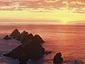
Many other islands are eroded remnants of volcanic rock – for example, the Poor Knights, Hen Island, Little Barrier and the Mercury and Alderman islands off the Coromandel coast, and the Sugar Loaf Islands (Ngā Motu) near New Plymouth.