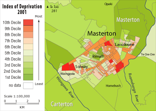
In 2001, Masterton’s affluent residents were concentrated in the hill suburb of Lansdowne and the leafy area around Renall Street. The town’s poor lived in Masterton East – a state housing area – and in areas close to industries that once employed large numbers. These include Solway (near the former Waingawa freezing works) and Masterton West (near the railway station). The map also highlights Wairarapa’s urban/rural divide – residents of the surrounding countryside are wealthier than those in the town. Many living on Masterton’s outskirts are on lifestyle blocks.
Te whakamahi i tēnei tūemi
David Bateman Ltd
Reference:
Crampton, Peter, and others. Degrees of deprivation in New Zealand: an atlas of socioeconomic difference. Auckland: David Bateman, 2000.
This item has been provided for private study purposes (such as school projects, family and local history research) and any published reproduction (print or electronic) may infringe copyright law. It is the responsibility of the user of any material to obtain clearance from the copyright holder.


Tāpiritia te tākupu hou