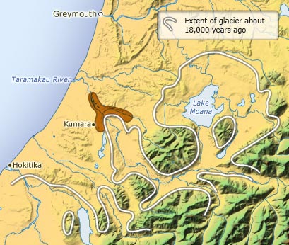

During glacial periods a major glacier extended down the Taramakau River valley. This map shows the extent of the glacier in the later part of the last glaciation, about 18,000–20,000 years ago. Alluvial gold was concentrated in river gravels in front of the glacier, and one of the richest areas was near Kumara. Click on the thumbnail to see a photograph of the Kaniere dredge working these gravels.
Te whakamahi i tēnei tūemi
Te Ara - The Encyclopedia of New Zealand
Source: R. P. Suggate and T. E. Waight, Geology of the Kumara-Moana area. Geological map 24. Lower Hutt: Institute of Geological and Nuclear Sciences, 1999
This item has been provided for private study purposes (such as school projects, family and local history research) and any published reproduction (print or electronic) may infringe copyright law. It is the responsibility of the user of any material to obtain clearance from the copyright holder.