Northern islands
Offshore islands dot the coast from Coromandel to Colville Bay, including Motutapere, Waimate and Motuoruhi. Many are little more than large rocks.
Most of the larger islands were purchased by Europeans in the mid-19th century. Motuoruhi and many of the smaller ones remain in Māori ownership. The Crown-owned islands now fall within the Hauraki Gulf Marine Park; all are wildlife sanctuaries.
Coromandel to Papaaroha
A stretch of the Coromandel coast popular with holidaymakers. The flowering pōhutukawa along this coast and all the way to Cape Colville rival those nearer Thames.
Ōamaru Bay is 6.5 km past Coromandel town. Nearby Kōpūtauaki has a rich history. The bay was used by Ngāti Porou trading vessels as a way station between the East Coast and Auckland before they acquired Kennedy Bay. The trespass of miners onto ground at Kōpūtauaki in 1862 angered the Māori owners. A visit to the area by Governor George Grey helped avert conflict.
Papaaroha has a large holiday park, and Amodeo Bay and Waitētē have many beach houses.
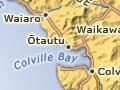
Colville
The most northerly settlement on the Coromandel Peninsula. James Cook named the tip of the peninsula Cape Colville, and the passage across to Great Barrier Island Colville Channel, after his former naval commander, Lord Colville. Colville Bay was first known as Cabbage Bay by Europeans. The name was changed in the early 20th century.
Kauri timber in the Colville catchment was milled at an early stage. In the early 2000s the hills still had a cut-over appearance; native regeneration had a long way to go. Recent plantings of radiata pine cover many slopes. Sheep and cattle are farmed on the river flats.
Isolation and the beautiful landscapes first drew counter-culture communities to the Colville area in the 1970s. Some of these still existed in 2010, including the Buddhist Mahamudra Centre and the Mahana community.
From Colville the western coast road passes through Ōtautu, Waiaro and Waitoitoi to reach Port Jackson, which has a long open beach. A road across the base of the Moehau Range divides to reach both Waikawau and Port Charles. In 2006 environmentalists raised the idea of making the northern tip a ‘mainland island’ nature reserve by erecting a pest-proof fence across the Peninsula from Colville to Waikawau. Local opposition has stalled the idea.
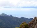
Moehau
The rugged northern end of the peninsula takes its name from its highest peak, Moehau (892 m).The burial place of Tamatekapua, captain of the Arawa canoe, the mountain is sacred to Māori. The 60-ha tract of Māori-owned land at the summit is known as Ngāti o Moehau.
Subalpine flora
The highest vegetation on Moehau is a small herbfield, a botanical community otherwise found no further north than the Ruahine Range in the lower North Island.
The main track up Moehau is from the Colville–Port Jackson Road starting at Te Hope stream.
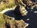
Coromandel coastal walkway
The two coastal roads of the peninsula’s far north – one to Jackson Bay and the other to Port Charles – fall slightly short of each other. They are connected by a popular walkway between Fletcher Bay and Stony Bay, which takes three to four hours.
Cuvier Island (Repanga Island)
Volcanic island which lies between Great Barrier Island (Aotea Island) and the Mercury Islands (Iles d'Haussez). A lighthouse, built in 1889, was staffed until 1982. The entire island became Crown land in 1957.