
A ‘Great New Zealand Ice Period’?
In the mid-19th century a Swiss scientist, Louis Jean Agassiz, promoted the idea that northern Europe’s glaciers were the remnants of an ancient and more widespread glaciation. He pointed out striated rock surfaces and moraines (gravel deposits) that could only have been created by glaciers. Geologist Ferdinand Hochstetter noticed that Nelson’s Lake Rotoiti resembled the moraine-dammed lakes he had seen in Italy, and saw it as possible evidence of a similar glacial period in New Zealand.
Lyrical landscapes
Julius Haast loved the outdoors, and delighted in the scenery while he studied the landscape. In 1861, describing the headwaters of the Rangitātā River, he wrote lyrically of ‘beautiful waterfalls’, mountains ‘towering to the blue heaven’, and glaciers ‘shining like molten silver’.
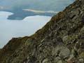
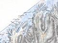
Julius Haast extended Hochstetter’s work. He found evidence – including lakes and fiords made by glacial erosion, and other landforms shaped by glacial deposits – to support what he called the ‘Great New Zealand Ice Period’. Haast mapped numerous moraines in the Southern Alps that marked the extent of glaciers at different periods.
Glaciers and the Canterbury plains
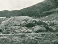
Haast compared small gravel fans in the Southern Alps with the immense fans that made up the Canterbury Plains and could be traced up the valleys to glacial moraines. If little streams could form small fans, he surmised, then the Canterbury Plains ‘were formed by the deposits of huge rivers issuing from the frontal end of gigantic glaciers’. 1 Some contemporary scientists, including Otago provincial geologist Frederick Hutton, refused to believe that glaciers could create landforms, claiming instead that the gravel plains were uplifted sea-bed deposits. But Haast’s view was soon widely accepted.
The extent of glaciers
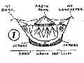
New Zealand, like Europe, had undergone a major glaciation, but there was debate over its extent. In 1910 James Park, professor of mining at Otago University, suggested that glaciers had once covered much of New Zealand, and were part of a vast ice sheet originating in Antarctica. This theory was disputed by Patrick Marshall, professor of geology at the university, and there was a vigorous public debate. The issue was settled in Marshall’s favour when Leslie Adkin, a young amateur geologist, showed that only the highest peaks of the North Island’s Tararua Range had been affected by glaciers.
Multiple glaciations
In the first decade of the 20th century the Austrian earth scientists Eduard Bruckner and Albrecht Penck identified four distinct European ice advances or glacial periods, separated by interglacial periods. It was not known if these were local or global, but a search began to correlate the European ice advances with those in New Zealand and elsewhere. By the 1920s, Robert Speight and other geologists had found evidence for multiple glacial periods in New Zealand.
Today, it is agreed that in the last 2.5 million years there have been about 30 global periods of glaciation, alternating with warm periods (interglacials), when the climate was similar to that of today. Almost all the glacial deposits now seen in the South Island are from the last two or three glacial periods. The deposits from earlier ice ages have been largely obliterated by erosion.