

Unlikely discoverers
A few minor geographical puzzles remained after James Cook’s charting of the New Zealand coastline. They were not all solved by navigators or explorers; some were solved by Europeans who had sailed out of Sydney to catch seals or whales, or trade in timber and flax.
Island and peninsula
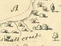
James Cook’s two main misconceptions about the coast of the South Island were corrected in the early 19th century. An American sealer, Owen F. Smith, became the first westerner to discover Foveaux Strait in 1804, disproving Cook’s idea that Stewart Island might be joined to the South Island. The existence of the strait was reported in Sydney in 1809 by Captain S. Chase of the Pegasus. In the same year, by trying to sail between what Cook had called Banks Island and the South Island’s east coast, Chase also discovered that the island was in fact a peninsula.
Far to the south
The sub-antarctic islands that are part of New Zealand’s territory were discovered both by British naval vessels, in the South Seas as a result of growing British imperial interest in the region, and by sealers and whalers. Captain William Bligh of the Bounty discovered the Bounty Islands in 1788, and Captain Henry Waterhouse of the Reliance located the Antipodes Islands in 1800. A whaling captain, Abraham Bristow, came upon the Auckland Islands in 1806, and a sealing captain, F. Hasselburgh, discovered Campbell Island in 1810.
Discovery and exploration
Early missionaries also contributed to growing knowledge about the New Zealand coast. On visits to New Zealand in 1814–15 and 1820, Samuel Marsden helped chart the Hokianga, Kaipara, Manukau and Waitematā harbours, and the Firth of Thames. Marsden also penetrated well inland. He stands at the point where the discovery and charting of the coastline develops into the exploration of the interior. Discovery and exploration overlapped in a continuous process.
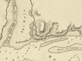
When the earliest attempt at organised settlement was made in 1826 by the first New Zealand Company, Captain James Herd contributed to knowledge of the coastline by charting Otago Harbour and Port Nicholson.
Whalers continued to make minor discoveries around the coast well into the 19th century. In September 1838 a whaler, John Guard, piloted the naval vessel Pelorus into the sound between Queen Charlotte Sound and Admiralty Bay. The sound was named after the ship.
Definitive charts
The very last chapter in the European discovery of New Zealand was the detailed charting of its coasts between 1848 and 1855 by those aboard the British ships Acheron and Pandora. The completion of these surveys was followed by the publication in 1856 of the first New Zealand Pilot by the Hydrographic Office of the Admiralty. These charts remained the basis for navigation around much of New Zealand until well into the 20th century.
Honouring the navigators
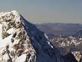
While he was at Jackson Bay in 1851, Captain John Lort Stokes of the Acheron named New Zealand’s highest peak Mt Cook, after the greatest of New Zealand’s European discoverers. His example was followed by Canterbury’s explorer and geologist Julius von Haast, who named the second-highest peak Mt Tasman in 1862.
Subsequently, the name of another English explorer, William Dampier, was given to New Zealand’s third highest mountain (even though Dampier had never visited New Zealand). Two peaks near Mts Dampier and Cook were named in the later 19th century after Zachary Hicks, the second-in-command on Cook’s first voyage, and the French explorer, La Pérouse. In the mid-20th century the names of two more early navigators, Vancouver and Malaspina, were conferred by historically minded mountaineers on minor peaks on the ridge between Dampier and Tasman.
These commemorations were a fitting postscript to the story of the European discovery of New Zealand. Equally fitting, as a reminder that the land they ‘discovered’ had already been inhabited for several centuries by Māori, the country’s highest peak now bears two official names: Aoraki and Mt Cook.