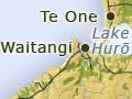
Waitangi, Te One and Port Hutt
Waitangi has the main wharf, a hospital and resident doctor, post office, bank, council office, police, several stores, a hotel and other accommodation. Nearby Lake Hurō once provided waterfowl and eels for locals. Whangamarino farm lies between Waitangi and Te One. Te One has an Anglican church and the main primary school on the islands.
A war memorial
Whakamaharatanga marae at Te One was built in 1946 as a memorial to the Chatham Islanders who served overseas in the New Zealand armed services in the world wars, and in memory of 11 men who drowned in 1931 on a voyage from Kāingaroa to Ōwenga – one of the worst of the islands’ many maritime tragedies.
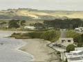
The world’s largest recorded whale stranding, of around 1,000 pilot whales, took place on Long Beach in 1918. Shallow reefs at Port Hutt are home to a variety of marine life.
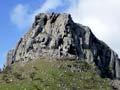
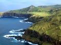
The north-west peninsula
In the north and north-west of the main island, schist outcrops contrast with an east–west line of seven volcanic cones surrounded by sedimentary rock. Dinosaur fossils have been found along the Tīoriori coast between Ngātikitiki Stream and Tutuiri Creek, one of only three such sites in New Zealand.
Edward Chudleigh ran sheep on the 13,000-hectare Wharekauri station from the 1860s until 1909 – Mt Chudleigh (188 m) was named after him. In 1973 the station was bought by the Crown.
Between 1866 and 1868 German Lutheran missionaries Johann Engst and Johann Baucke built a house, still standing in 2012, under the Maunganui bluff (178 m), on land they were farming to the west of Chudleigh’s station.
The north-east peninsula
Kāingaroa is the most north-eastern settlement on the main island. The Chatham anchored offshore from there in 1791. From 1839 the district was home to Ngāti Tama, many of whom returned to Taranaki in 1868.
Te Whakarau, at the extreme north-east of the island, was the home of the island’s first resident magistrate, Archibald Shand, who held the position from 1855 to 1863.
Thomas Ritchie ran sheep at Ōkawa Point from 1864 and later leased land at Kāingaroa, where his successors, the Barkers, were still farming in 2000. A fish-freezing business operated throughout the 20th century. The settlement thrived during the crayfish boom.
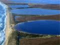
Te Whanga Lagoon
The 16,000-hectare Te Whanga Lagoon is more than twice the size of Wellington Harbour.and accounts for 20% of the area of Chatham Island. Formerly a deep bay, it has been enclosed by sand dunes to its east, but occasionally opens to the sea. The island’s airfield is located on the north-west side of the lagoon, at Kārewa Point.
Te Awapātiki, at the main opening between the lagoon and the ocean, is a sacred place for Moriori. The name also refers to the block of land running south from the lagoon entrance.
The southern plateau
The southern third of Chatham Island is a huge block of basaltic volcanic rock, tilted so that there are high cliffs in the south.
Soils are peat or peat-derived, with tarahinau (Dracophyllum arboreum) still widespread.
Ōwenga, Manukau Point
Ōwenga was possibly the first place settled on the main island. The Ritchie brothers ran sheep on a 3,700-hectare station in the area from 1866 until the early 1890s. A fish-freezing business operated from 1910 to 1937. Ōwenga also benefited from the crayfish boom of the late 1960s and early 1970s.
In the 2000s Ōwenga was the departure point for boat travel to Flower Pot (Onoua) on Pitt Island.
Manukau Point is the south-easternmost point of the main island. The sole Moriori reserve on the island remaining in 2012 was established here in 1870. It has been an important centre for Moriori ever since.
The 51st state?
By 1860 Pitt Island had captured the bulk of the American whaling trade in the Chathams. ‘In the season’, wrote an 1881 visitor, ‘there are frequently several American whalers at anchor off the island ... [T]he Massachusetts whalers make Pitt Island their chief depot in their cruises in these seas, so much so that the islanders are really more familiar with the “Stars and Stripes” than with the “Union Jack”’.1
Pitt Island
Pitt Island is hillier than the main island and has few lakes or sandbars. Pitt was historically home to two of the nine Moriori imi (tribes). It was the principal ‘port of call’ in the Chatham Islands during the revival in whaling in the early 1860s.
The northern part of Pitt Island has large areas of broadleaf forest and rich soils; the southern part has tarahinau-covered bogs and hills. In 2012 day trips could be made by air to Pitt Island from Chatham Island, and a launch plied the route between Ōwenga and Flower Pot on Pitt Island.
Small islands near Pitt Island
Several small islands, all volcanic outcrops, near Pitt Island – the most significant of which are South East Island (Rangatira) and Māngere – are nature reserves.
Chatham albatrosses breed on just one rocky island, Pyramid Rock, south of Pitt Island. In the early 2000s there were an estimated 4,575 breeding pairs.
South East Island (Rangatira) is noted for its abundance of large ground-dwelling insects, notably wētā and stag beetles. This was once the norm on the rest of the Chatham Islands and on the New Zealand mainland.