Antarctica is the coldest, driest, windiest and highest of the world’s seven continents. Snow and ice cover 95% of its area, and the seas that surround it are frozen for much of the year. It was the last continent to be discovered, and it had no human inhabitants.
Terra australis incognita
Europeans assumed the existence of an unknown land in the south, ‘terra australis incognita’, for thousands of years. The Flemish cartographer Rumold Mercator included it on his 1587 map of the world. Finding the southern continent was one of the objects of Dutch explorer Abel Tasman’s voyage of discovery when, in 1642, he became the first European to sight New Zealand.
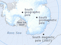
Antarctic and Antarctica
Although ‘Antarctic’ and ‘Antarctica’ can be used to refer to different things, the two terms are so similar that many people use them interchangeably. Strictly speaking, Antarctica is the continent that surrounds the South Pole. ‘Antarctic’ refers to the entire southernmost region of the earth. It includes Antarctica and the surrounding ice shelves and sea.
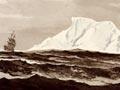
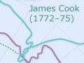
British navigator James Cook visited New Zealand during each of his three voyages of discovery. On his second voyage he was specifically commissioned to search for terra australis incognita, and in doing so he circumnavigated the globe, frequently sailing below 60° south. On 17 January 1773 Cook and the crew of the Resolution became the first people to cross the Antarctic Circle (at latitude 66° 33’ south). Although Cook’s second voyage proved that neither Australia nor New Zealand was attached to a southern continent, he and his men did not sight Antarctica. Despite encountering icebergs during the Resolution’s southerly circumnavigation, the voyage did not confirm the existence of southern lands.
Antarctica sighted
In 1820, on separate expeditions, Russian admiral Fabian von Bellingshausen, Royal Navy master Edward Bransfield and American captain Nathaniel Palmer all sighted the southern continent.
Bellingshausen visited New Zealand after seeing the ‘mountainous ice’1 of Antarctica. During the next two decades, sealers and explorers continued to visit the Antarctic, some using New Zealand as either a base before or a haven after making discoveries. They included:
- John Balleny, an Enderby sealing company captain who discovered the Balleny Islands in 1840
- Dumont d’Urville, a French admiral who found the Adélie Land coast of Antarctica in 1840
- Charles Wilkes of the United States Exploring Expedition, whose mapping in 1839–40 provided evidence of the southern continent
- James Clark Ross, the British Royal Navy officer who in 1840–41 discovered the Ross Sea, McMurdo Sound (named after an officer on the expedition), Ross Island and Mt Erebus (named after one of Ross’s two ships).
First New Zealander
Tuati, also known as John Sac, the son of a Scottish whaler and sealer and his Ngāpuhi wife, saw Antarctica in 1840 while a seaman with the Wilkes expedition. This first sighting by a New Zealander was commemorated 150 years later, when Tuati Peak in Antarctica’s Royal Society Range was named after him.
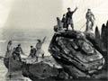
Landfall
In January 1895 a party from the Antarctic – a whaling and sealing ship owned by Carsten Borchgrevink, a Norwegian resident of Australia – set foot on Cape Adare. It was the first recognised landing by people on the continent of Antarctica. The group included a young New Zealander, Alexander von Tunzelmann.