

Maruia valley
Maruia means sheltered or shady in Māori. From its source in the Southern Alps, the Maruia River flows south-west, then gradually turns almost 180 degrees to flow north to join the Buller River near Murchison (in the adjacent Nelson region).
Maruia Declaration
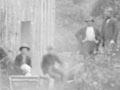
Concerned about the proposed clearfelling of native timber, a group of 40 conservationists signed a petition to save lowland forests around a campfire on the snow-covered banks of the Maruia River near Lewis Pass on 4 July 1975. This became known as the Maruia Declaration. When circulated around New Zealand it attracted over 340,000 signatures. Although not accepted by the government of the day, it eventually became a blueprint for the conservation of native forest.
Cannibal country
The steep gorge of the Maruia River, leading up to the Lewis Pass has the Māori name of Kopi o Kaitangata, often translated as Cannibal Gorge. On long trips this was traditionally a place where one or more slaves were slaughtered to provide food for the rest of the party.
Lewis Pass
The Lewis Pass (864 m) links the West Coast with North Canterbury. It was known to Māori travellers as a trading route for the transport of pounamu (greenstone or jade). The first Europeans recorded to cross the pass were Nelson surveyors Henry Lewis (after whom it is named) and C. Maling in the early 1860s. The pass was used by early Pakēhā travellers, but was regarded as too far north to give useful access to the goldfields. A road across the pass (State Highway 7) was completed in 1938, and is used by travellers from Canterbury to the northern part of the West Coast and to Nelson.
Maruia Springs
Warm volcanic springs occur naturally on the north bank of the Maruia River, about 5 km west of Lewis Pass. The water is piped across the river for use in warm pools at the Maruia Springs thermal resort, where there is sex-segregated bathing in a Japanese-style bathhouse, as well as outdoor rock pools.
Earthquakes past
In 1950 geologist Harold Wellman discovered evidence for several past ruptures on the Alpine Fault at the Marble Hill picnic area. He showed that the highest terraces were more offset than the lower ones, which could only be explained by multiple movements, each of which would have been accompanied by a large earthquake. It is possible to walk along the line of the fault – from the concrete wall as a starting place – and estimate how much each terrace has been offset.
Marble Hill picnic area
The Maruia River opens out near the junction with the Alfred River, where there are wide river flats, recreational facilities and several short walks. A longer track leads to a hut at Lake Daniells. This is also one of the few accessible sites where the Alpine Fault – the largest fault in New Zealand – can be seen. A concrete wall was built across the fault line in the 1960s to check whether it was moving very gradually, but by 2015 there had been no sign of movement.
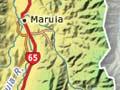
Springs Junction
A small settlement near the junction of State Highway 7 (to Reefton) and State Highway 65 (to Murchison). The name is misleading because Maruia Springs is 16 km to the east.
Close to the settlement, the Maruia River swings to the north, and State Highway 65 follows it for 65 km to the junction with the Buller River. State Highway 7 continues through beech forest over the Rahu Saddle towards Reefton.