The most direct route by road from Canterbury to the central part of the West Coast is over Arthur’s Pass (920 m), and down the Ōtira and Taramakau valleys to the sea. The Canterbury side is a relatively easy road, but on the western side of the pass the upper section of the Ōtira valley is a steep gorge, prone to landslides and rockfalls. Keeping the road open, especially for larger vehicles such as buses and milk tankers, is a continuing engineering challenge. The scenery is spectacular, and the Ōtira gorge has often been painted and photographed.
Arthur’s apostrophe
Arthur’s Pass was discovered by – and named after – Arthur Dobson in 1864, when there was a search to find a navigable pass across the Southern Alps. Years later the New Zealand Geographic Board decided that place names in New Zealand would not have apostrophes. Because the spelling of Arthur’s Pass was long established, the apostrophe has been retained, making it the only geographic feature on the West Coast officially spelt with an apostrophe.
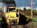
The railway from Canterbury to the West Coast generally follows the same route as the road, but a tunnel was required between Arthur’s Pass and Ōtira. The 8.5-km tunnel was an ambitious undertaking when started in 1907, as it would then have been one of the longest tunnels in the world. Plagued by problems, it was not finally opened until August 1923. Since then the railway has carried raw materials from the West Coast to Canterbury, with much smaller amounts of freight going in the opposite direction. In the 2010s the railway mainly transported coal to be exported from Lyttelton. There is also a daily passenger train, the TranzAlpine, from Christchurch to Greymouth and back to Christchurch, which attracts many tourists.
Ōtira
Locality on the western side of Arthur’s Pass, 82 km south-east of Greymouth. Originally founded for construction workers on the Ōtira tunnel, it became a settlement for railway workers. The town was sold by the railways in 1999, and in the 2010s only a few dozen residents remain. It is mainly a base for tramping and mountaineering.
Jacksons
Locality on State Highway 73, 68 km south-east of Hokitika. Adam Jackson built the first accommodation house here, and a number of hotels have been built at this locality. The only bridge across the Taramakau River near Jacksons is found 1 km west, at the junction of a road to Lake Brunner (Moana) and the Grey Valley.
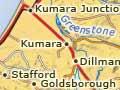
Kumara
Township on the west side of the Taramakau River, 25 km south of Greymouth, with a 2013 population of 309. It was named in 1863 by surveyor Arthur Dobson after a distortion of kohimara, the Māori word for the spectacular flowers of the bush lawyer.
Seddon country
One of the first people to move to Kumara after gold was discovered in 1876 was shopkeeper Richard Seddon, who opened a hotel and became mayor. He moved into national politics and became premier from 1893 to 1906, but never forgot his roots in Kumara. For many years one of his favourite topics, on which he would speak at length, was the Waimea sludge channel.
The area around Kumara was overlooked in the 1860s gold rushes, but in 1876 coarse gold was found in glacial gravels, leading to the West Coast’s last major gold rush. There was considerable overburden (a gravel layer above the gold), so hydraulic sluicing was the only feasible way to recover the gold. In the next 20 years huge water races and sludge channels were constructed, and much of the country behind Kumara (including the adjacent settlement of Dillmanstown) was sluiced away into the Taramakau River. Mining declined in the late 1890s, but dredging continued in the Taramakau valley until the 1960s.
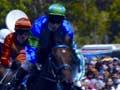
The Kumara Racing Club held its first meeting in 1887. In the 2010s its annual meeting on the second Saturday in January is the largest event in the town, with many of the traditional features of country races that have disappeared from larger clubs.
Kumara Junction is 7 km north-west, at the intersection of State Highway 6 with State Highway 73. It is close to the start of the annual Coast to Coast race, held in early February, which crosses the South Island, and includes cycling, mountain running and kayaking.