
Following the discovery of high-quality bituminous coal at Burnetts Face in 1860, thick coal seams were found at several nearby localities. It was gradually realised that the Buller coalfield extended more than 30 kilometres along a high plateau (500–600 metres above sea level), from Denniston to Seddonville. Much of this area carries only stunted vegetation because of the infertile nature of the coal-bearing rocks.
Communities grew up close to the major mines, often in remote localities. The 1911 census showed that a substantial population was living in coal towns:
- Seddonville: 525
- Millerton: 708
- Granity/Ngākawau/Hector: 882
- Denniston (including Burnetts Face): 1,469
- Waimangaroa: 362.
Life in the mining communities on the plateau was bleak. As motorised transport became available, mining families gradually moved down to coastal locations with a better climate.
Hell-fire coal
Coal from Seddonville was traditionally hard to sell because of its exceptionally high sulphur content (generally 5–6% and sometimes more). Brimstone, the pungent smell of sulphurous coal burning, is traditionally associated with hell. In the late 20th century Seddonville coal was banned from most urban areas, and one of the few places where it was used was the Karamea dairy factory.
Seddonville
Township on river flats in the lower reaches of the Mōkihinui River, 50 km north-east of Westport. It was named after Premier Richard Seddon, who visited the area in 1893. New Zealand’s first state coal mine was opened at Seddonville in 1903, but closed in 1914 because of mining difficulties. A number of private mines worked coal during the 20th century, but mining has now ceased.
Millerton
High-altitude settlement, 31 km north-east of Westport. Named after H. J. Miller, a director of the Dunedin-based Westport Coal Company, Millerton was opened as a company town for miners at the nearby Millerton Mine in 1896. Few miners still live in Millerton, but a small community survives, attracted by cheap land and housing.
Opencast mines from the plateau behind Millerton provide a large proportion of the bituminous coal produced in New Zealand. The coal is transported on an aerial cableway to storage bins at Ngākawau, then taken by rail to Christchurch.
Charming Creek walkway
A railway line to the abandoned Charming Creek mine has been converted into an easy, 5.5-kilometre walkway through native forest. The first part is through the spectacular Ngākawau Gorge, which is crossed by a suspension bridge near the Mangatini falls. An all-weather track, this is an exciting walk on a wet day when the river is in flood, and the falls are deafening.
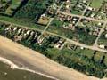
Granity, Ngākawau and Hector
The narrow coastal flat near the mouth of the Ngākawau River, 32 km north-east of Westport, has an almost continuous strip of housing (2013 population: 456). There are three distinct mining settlements. Granity is situated at the bottom of the hill road to Millerton. Ngākawau is on the south side of the Ngākawau River, named after the shags (kawau in Māori) that nest nearby. The settlement of Hector, on the north side of the river, is named after James Hector, a 19th-century geologist who studied the Buller coalfield.
The open, boulder-strewn coast is one of the best places on the West Coast to collect wave-polished stones.
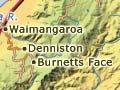
Denniston
A small, almost abandoned coal town, 27 km north-east of Westport. It was named after R. B. Denniston, manager of the first major mine to open in the 1870s and later a director of the Westport Coal Company. On a bare plateau at an altitude of 600 metres, Denniston was the bleakest of the coal mining towns, often shrouded in fog. The nearby town of Burnetts Face was squashed into a narrow valley, close to the original coal discovery. Jenny Pattrick’s novel The Denniston rose (2003) gives a depressingly vivid picture of the lives of miners and their families.
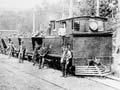
Coal was transported from the plateau down to a branch railway line by the Denniston incline, a spectacular cable railway. Mining ceased in the 1990s, and only a few inhabitants remain. Part of the town is a historic reserve, with a museum and walking tracks around mining relics.
Waimangaroa
A small mining and milling town, 17 km north of Westport, at the foot of the winding road up to Denniston.