

Greymouth
2013 population: 9,654
The largest town and administrative centre of the West Coast, near the mouth of the Grey River/Māwheranui, and 233 km west of Christchurch. Squeezed between the hills, the river and the sea, as the population increased the town gradually expanded to the south. The main suburban areas are Blaketown, Boddytown, Coal Creek, Cobden, Karoro and South Beach.
History
A Māori settlement at Māwhera pā was long established on the south bank of the Māwheranui river. When the first European explorers, Thomas Brunner and Charles Heaphy, arrived in 1846, they stayed at the pā, and were given food. Two years later Brunner travelled up the river, which he renamed after Governor George Grey.
James Mackay negotiated with local Māori chiefs for purchase of the West Coast region by the government, and the agreement was signed at Māwhera pā on 21 May 1860. One of the few Māori reserves was the land around the pā, now forming the main business district in Greymouth, and most of this still remains in Māori ownership.
Beer boycott
In October 1947 hotels on the West Coast increased the price of a 10-ounce glass of beer from 6 to 7 pence (which was then the standard price elsewhere in New Zealand). Following widespread protests, the West Coast Trades Council (representing the major unions) called for a boycott of hotels selling beer at the higher price. The only hotel in Greymouth to sell beer at the old price did a roaring business while others were deserted.
Union solidarity triumphed after several weeks, and beer returned to its old price.
The boundary between Nelson and Canterbury provinces was drawn along the Grey River/Māwheranui. Separate settlements grew up on opposite sides of the river in the early 1860s – Cobden on the north, and Greymouth on the south. Both were laid out by surveyor John Rochfort. With the discovery of gold in the Taramakau valley to the south in 1864–65 and subsequent gold rushes the settlements grew, but it was soon obvious that Greymouth was better sited for a port than Cobden.
Gradual development
Coal was exported from the port of Greymouth from the 1870s, followed by timber. These provided the foundation for the local economy as the boom days of gold passed. By 1881 the population of Greymouth was greater than Hokitika’s, and since then it has been the largest centre on the West Coast.
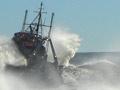
Activity at the port of Greymouth gradually declined through the 20th century, especially after the opening of the Ōtira railway tunnel in 1923, and it is now mainly used by fishermen. Bulk commodities such as coal are transported to Christchurch by rail. But the decline of the port has been largely offset by growth in the tourism and farming sectors.
Vicious wind
A notorious, chilly wind streams down the Grey Valley in the morning, funnelled through the Grey River/Māwheranui gap, and marked by a trail of white mist. It is locally known as ‘the barber’, reputedly because it cuts you to the bone.
The central part of Greymouth was regularly flooded when a high tide coincided with a flood in the Grey River/Māwheranui. A flood wall (locally known as ‘the great wall of Greymouth’) now protects the town, and provides a pleasant walk along the south side of the river.
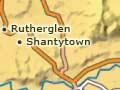
Shantytown
A replica West Coast gold-mining town, about 10 km south of Greymouth. Constructed as a community effort in the early 1970s, Shantytown includes a number of historic buildings that were moved to the site. It illustrates the early life of the West Coast, and includes gold panning, a steam train, a sawmill, and Chinatown.