
South of Hokitika, State Highway 6 passes through areas of cleared river flats interspersed with forest-covered hills. The area was heavily glaciated during past ice ages, and much of the hilly country is glacial moraine (rock) containing large boulders. The river flats are gravel terraces formed after the glaciers melted. Dairy farming is the main industry, supplemented by a growing tourism sector.
Gigantic gold
New Zealand’s largest gold nugget, weighing 99 ounces and 12 pennyweight (2.807 kilograms) was discovered at Ross by two prospectors in 1909. Nicknamed the Honourable Roddy after the minister of mines (Roderick McKenzie), it was purchased by the government and presented to King George V as a coronation present in 1911. Sadly it no longer exists – it was melted down for a royal tea service.
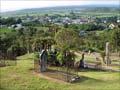
Ross
A small historic town with a 2013 population of 297, 31 km south-west of Hokitika.
Ross was the centre of one of New Zealand’s richest alluvial goldfields in the late 19th century, with extensive underground mining and sluicing claims. The town sprang up after discoveries in 1864–65, and was named after the Canterbury provincial treasurer, George Ross. Surface gravels were rapidly worked out, but gold was found beneath Ross flat. Companies were formed to develop underground mines. Although profitable, underground mining had ceased by 1915, defeated by drainage problems. A large opencast pit was opened in the 1990s to recover gold from previously inaccessible areas, and is now filled by a lake at the southern end of the township.
There are several walking tracks around old mining areas in Ross, as well as a museum and visitor centre.
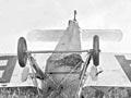
A Harihari landing
Australian Guy Menzies completed the first solo trans-Tasman flight on 7 January 1931, landing upside down in a swamp at Harihari. The flight took 11 hours 45 minutes, and is commemorated in a memorial at Harihari. On the 75th anniversary, in 2006, Dick Smith undertook a similar flight, but decided to land upright.
Harihari
A farming township with a 2013 population of 330, on the Wanganui River flats, 73 km south of Hokitika. The river flats were originally forest-covered. For much of the 20th century the town was a forestry centre, supporting several sawmills. The flat land has been progressively cleared, drained and converted to pasture.
South Westland Area School, based in Harihari, provides education for pupils from years 1–13 from the surrounding region.
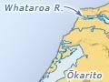
Whataroa
A small rural locality on the south side of the Whataroa River, 103 km south-west of Hokitika. Whataroa is a base for guided nature tours over summer months. The only New Zealand breeding colony of kōtuku (white herons) is on the banks of the Waitangiroto River. They arrive about September each year and, after breeding, leave around January. The colony is a nature reserve, requiring an entry permit.
Ōkārito
A coastal settlement on the edge of Ōkārito Lagoon, 135 km south-west of Hokitika. The name is related to the raupō (bulrushes) around the lagoon – kārito means young raupō shoots. Ōkārito grew up as a gold-rush town in 1865–66, with a population of 1,250 in May 1866. In the 2010s a small community remains, and there is motel and backpacker accommodation as well as a camping ground.
Ōkārito Lagoon
Covering more than 2,000 hectares of shallow open water and tidal flats, Ōkārito Lagoon is the largest unmodified wetland in New Zealand. On the landward site it is surrounded by conifer–broadleaf forest, including stands of huge kahikatea and rimu. The lagoon is well known as a bird-watchers’ paradise, and over 70 native species have been identified.
In recognition of the importance of Ōkārito Lagoon to local Māori, Ngāi Tahu were granted statutory acknowledgement over the lagoon as part of their 1998 Treaty of Waitangi settlement, including designation of a nohoanga (coastal occupation site).