
Ōakura
Coastal town 13 km west of New Plymouth on State Highway 45, with a 2013 population of 1,380. The Kaitake Range shelters the town from cold southerly winds. Ōakura has been a sought-after residential area for many years because of its environment and fine beaches. Many lifestyle blocks have recently been developed on surrounding farmland.
In May 1863 the first conflict of the second Taranaki war took place near the mouth of the Wairau Stream on Ōakura beach, when 10 officers and men of the 57th Regiment were ambushed. Nine, including Captain Thomas Tragett, were killed. St Andrews Redoubt (1863) was put up after the Wairau ambush, on what is now private land overlooking Corbett Park and the Ōakura marae at the mouth of the river. Some of its earthworks survive.
Tātaraimaka
Settlement 22 km south-west of New Plymouth. The Tātaraimaka block was bought by the New Zealand Company in 1847, but was abandoned during the first Taranaki war (1860–61).
The Taranaki tribe’s coastal Tātaraimaka pā was seized in 1818 by a northern war party which used muskets for the first time in Taranaki. Beside the pā is the site of St George’s redoubt, built in 1863 after the block was reoccupied by British troops. Buried there are 28 Māori killed during the battle at Katikara in June 1863. The sites are historic reserves.
Ōkato
Town and rural service centre 26 km south-west of New Plymouth on State Highway 45, with a 2013 population of 561. Ōkato is one of the three surviving northern Taranaki military settlements established in the 1860s (along with Urenui and Lepperton).
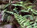
The Stony River (Hangatahua), which arises in the Ahukawakawa Swamp in Egmont National Park, flows past the western side of Ōkato. Blue Rātā Reserve on the banks of the river is home to a unique variety of northern rātā (Metrosideros robusta) which begins its life as a true tree. Usually northern rātā starts out as an epiphyte in the canopy of a host tree which it eventually overshadows.
Pūniho
Settlement 31 km south-west of New Plymouth. The Ngā Māhanga sub-tribe’s Tarawainuku marae is home to Te Toka-a-Rauhoto, in Māori tradition the guiding stone of Taranaki Maunga when he fled from the central North Island. The stone was relocated to Pūniho in 1948.
Wārea
Settlement 35 km south-west of New Plymouth, where the German missionary Johann Riemenschneider established a mission station in 1846. Two of his students, Te Whiti-o-Rongomai and Tohu Kākahi, later attained fame as the leaders of Parihaka’s passive resistance movement against land sales.
There were a number of military engagements in the area during the 1860s, and the 43rd Regiment built a redoubt on the coast near the end of Stent Road in 1865. The ocean swells of ‘Stent Road’ are one of New Zealand’s classic surf breaks.
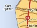
Pungarehu
Settlement 42 km south-west of New Plymouth and 23 km north of Ōpunake, established as a base for the 1881 military invasion of Parihaka pā a few km away.
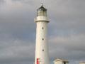
A shining light
The 20-metre-high cast-iron tower of Cape Egmont lighthouse, which stands on the westernmost point of Taranaki, was manufactured in Britain in 1864. Erected on Mana Island near Wellington in 1865, it was moved to Cape Egmont in 1881. The keepers lived alongside the lighthouse until it was automated in 1986. The original lens has been reinstalled in a replica – but non-functioning – tower at the Cape Egmont boating club.
Parihaka
The Māori village of Parihaka was established by Te Whiti-o-Rongomai and Tohu Kākahi among the lahar hills inland from Cape Egmont in the late 1860s, and became the centre of a passive resistance movement against confiscations of Māori land. In 1881 the township was invaded by more than 1,500 government and volunteer troops. The leaders were arrested and most of the residents forcibly dispersed.
After Te Whiti and Tohu’s returned, Parihaka again became a focus for Taranaki Māori. It declined in the mid-20th century, but was later rejuvenated. In 2006 it became the base for the annual Parihaka International Peace Festival.
Rāhotu
Township 16 km north-west of Ōpunake and 46 km south-west of New Plymouth, established in 1886. The anchor of the ship Harriet, wrecked nearby in 1834, is mounted outside the hotel. The military expedition to rescue crew members and the owner’s wife, Betty Guard, resulted in the first conflict between Māori and British troops.
Ōaonui
Ōaonui, 9 km north of Ōpunake, is the site of the Māui gas-field production station and information centre. Shell Todd Oil Services processes gas and condensate from the offshore Māui field here and pumps it to New Plymouth.
Ōpunake
Coastal town 64 km south-west of New Plymouth and 43 km north-west of Hāwera, with a 2013 population of 1,335. Ōpunake is the main rural service town for Taranaki’s coastal region.
On the coast just north of the town is Te Namu pā. In 1833 local chief Wiremu Kīngi Moki Matakātea held off a war party from Waikato for several weeks with a single musket, and eventually triumphed. In 1865 the Ōpunake redoubt was occupied by the 70th Regiment, but little trace of it remains.
Ōpunake Bay is a popular holiday spot and camping ground. The Egmont County Council was based in Ōpunake until it became part of South Taranaki District in 1989.
A branch railway to Ōpunake from the New Plymouth–Wellington line was laid in 1926. The section between Ōpunake and Kāpuni was closed in 1976.